You are here: Home > Network List > TA - USArray Transportable Network (new EarthScope stations) Stations List
> Station J43A Natural Harvest Farm, Hartford, WI, USA > Earthquake Result Viewer
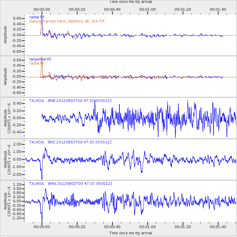
J43A Natural Harvest Farm, Hartford, WI, USA - Earthquake Result Viewer
| Earthquake location: |
Peru-Brazil Border Region |
| Earthquake latitude/longitude: |
-8.4/-74.3 |
| Earthquake time(UTC): |
2012/08/02 (215) 09:38:30 GMT |
| Earthquake Depth: |
145 km |
| Earthquake Magnitude: |
5.9 MB, 6.1 MW, 6.1 MW |
| Earthquake Catalog/Contributor: |
WHDF/NEIC |
|
| Network: |
TA USArray Transportable Network (new EarthScope stations) |
| Station: |
J43A Natural Harvest Farm, Hartford, WI, USA |
| Lat/Lon: |
43.38 N/88.42 W |
| Elevation: |
322 m |
|
| Distance: |
53.1 deg |
| Az: |
347.119 deg |
| Baz: |
162.391 deg |
| Ray Param: |
0.065808535 |
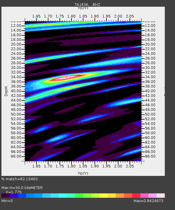
| Estimated Moho Depth: |
34.0 km |
| Estimated Crust Vp/Vs: |
1.77 |
| Assumed Crust Vp: |
6.571 km/s |
| Estimated Crust Vs: |
3.702 km/s |
| Estimated Crust Poisson's Ratio: |
0.27 |
|
| Radial Match: |
92.10483 % |
| Radial Bump: |
400 |
| Transverse Match: |
59.239616 % |
| Transverse Bump: |
400 |
| SOD ConfigId: |
469095 |
| Insert Time: |
2013-02-22 03:34:29.294 +0000 |
| GWidth: |
2.5 |
| Max Bumps: |
400 |
| Tol: |
0.001 |
|
Signal To Noise
| Channel | StoN | STA | LTA |
| TA:J43A: :BHZ:20120802T09:47:03.050012Z | 11.307324 | 1.029416E-6 | 9.103975E-8 |
| TA:J43A: :BHN:20120802T09:47:03.050012Z | 8.958965 | 5.672763E-7 | 6.33194E-8 |
| TA:J43A: :BHE:20120802T09:47:03.050012Z | 2.8018162 | 2.1073932E-7 | 7.5215254E-8 |
| Arrivals |
| Ps | 4.2 SECOND |
| PpPs | 14 SECOND |
| PsPs/PpSs | 18 SECOND |


