You are here: Home > Network List > TA - USArray Transportable Network (new EarthScope stations) Stations List
> Station O47A Sheridan, IN, USA > Earthquake Result Viewer
O47A Sheridan, IN, USA - Earthquake Result Viewer
| Earthquake location: |
Peru-Brazil Border Region |
| Earthquake latitude/longitude: |
-8.4/-74.3 |
| Earthquake time(UTC): |
2012/08/02 (215) 09:38:30 GMT |
| Earthquake Depth: |
145 km |
| Earthquake Magnitude: |
5.9 MB, 6.1 MW, 6.1 MW |
| Earthquake Catalog/Contributor: |
WHDF/NEIC |
|
| Network: |
TA USArray Transportable Network (new EarthScope stations) |
| Station: |
O47A Sheridan, IN, USA |
| Lat/Lon: |
40.24 N/86.17 W |
| Elevation: |
278 m |
|
| Distance: |
49.6 deg |
| Az: |
348.029 deg |
| Baz: |
164.451 deg |
| Ray Param: |
0.06807075 |
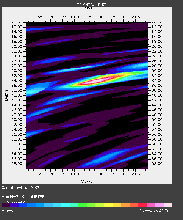
| Estimated Moho Depth: |
34.0 km |
| Estimated Crust Vp/Vs: |
1.88 |
| Assumed Crust Vp: |
6.498 km/s |
| Estimated Crust Vs: |
3.452 km/s |
| Estimated Crust Poisson's Ratio: |
0.30 |
|
| Radial Match: |
95.12082 % |
| Radial Bump: |
400 |
| Transverse Match: |
77.39915 % |
| Transverse Bump: |
400 |
| SOD ConfigId: |
469095 |
| Insert Time: |
2013-02-22 03:35:15.846 +0000 |
| GWidth: |
2.5 |
| Max Bumps: |
400 |
| Tol: |
0.001 |
|
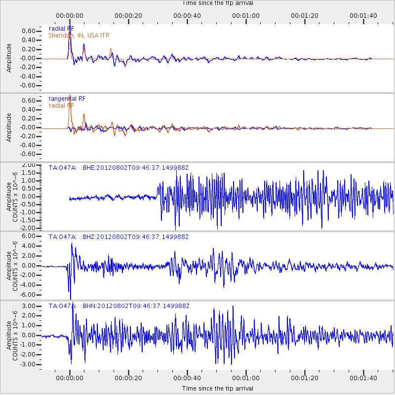
Signal To Noise
| Channel | StoN | STA | LTA |
| TA:O47A: :BHZ:20120802T09:46:37.149988Z | 34.543194 | 2.372287E-6 | 6.8675966E-8 |
| TA:O47A: :BHN:20120802T09:46:37.149988Z | 17.262238 | 1.2721921E-6 | 7.369798E-8 |
| TA:O47A: :BHE:20120802T09:46:37.149988Z | 7.484434 | 5.462517E-7 | 7.298504E-8 |
| Arrivals |
| Ps | 4.9 SECOND |
| PpPs | 14 SECOND |
| PsPs/PpSs | 19 SECOND |


