You are here: Home > Network List > TA - USArray Transportable Network (new EarthScope stations) Stations List
> Station R47A Wooly Knot Farm, English, IN, USA > Earthquake Result Viewer
R47A Wooly Knot Farm, English, IN, USA - Earthquake Result Viewer
| Earthquake location: |
Peru-Brazil Border Region |
| Earthquake latitude/longitude: |
-8.4/-74.3 |
| Earthquake time(UTC): |
2012/08/02 (215) 09:38:30 GMT |
| Earthquake Depth: |
145 km |
| Earthquake Magnitude: |
5.9 MB, 6.1 MW, 6.1 MW |
| Earthquake Catalog/Contributor: |
WHDF/NEIC |
|
| Network: |
TA USArray Transportable Network (new EarthScope stations) |
| Station: |
R47A Wooly Knot Farm, English, IN, USA |
| Lat/Lon: |
38.30 N/86.53 W |
| Elevation: |
181 m |
|
| Distance: |
47.9 deg |
| Az: |
346.968 deg |
| Baz: |
163.529 deg |
| Ray Param: |
0.06922048 |
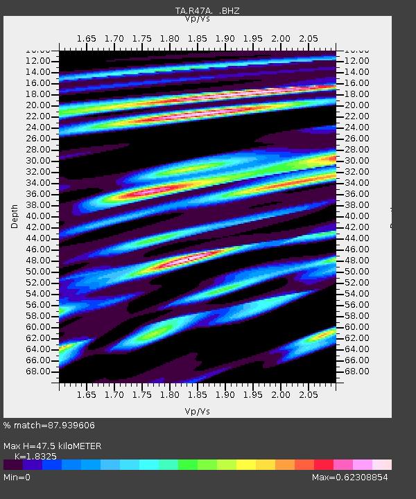
| Estimated Moho Depth: |
47.5 km |
| Estimated Crust Vp/Vs: |
1.83 |
| Assumed Crust Vp: |
6.444 km/s |
| Estimated Crust Vs: |
3.516 km/s |
| Estimated Crust Poisson's Ratio: |
0.29 |
|
| Radial Match: |
87.939606 % |
| Radial Bump: |
400 |
| Transverse Match: |
75.38654 % |
| Transverse Bump: |
400 |
| SOD ConfigId: |
469095 |
| Insert Time: |
2013-02-22 03:36:50.966 +0000 |
| GWidth: |
2.5 |
| Max Bumps: |
400 |
| Tol: |
0.001 |
|

Signal To Noise
| Channel | StoN | STA | LTA |
| TA:R47A: :BHZ:20120802T09:46:23.550012Z | 23.271307 | 1.067077E-6 | 4.5853767E-8 |
| TA:R47A: :BHN:20120802T09:46:23.550012Z | 7.3397017 | 4.96222E-7 | 6.760793E-8 |
| TA:R47A: :BHE:20120802T09:46:23.550012Z | 4.385583 | 1.3641127E-7 | 3.1104477E-8 |
| Arrivals |
| Ps | 6.5 SECOND |
| PpPs | 20 SECOND |
| PsPs/PpSs | 26 SECOND |


