You are here: Home > Network List > TA - USArray Transportable Network (new EarthScope stations) Stations List
> Station X47A Russelville, AR, USA > Earthquake Result Viewer
X47A Russelville, AR, USA - Earthquake Result Viewer
| Earthquake location: |
Peru-Brazil Border Region |
| Earthquake latitude/longitude: |
-8.4/-74.3 |
| Earthquake time(UTC): |
2012/08/02 (215) 09:38:30 GMT |
| Earthquake Depth: |
145 km |
| Earthquake Magnitude: |
5.9 MB, 6.1 MW, 6.1 MW |
| Earthquake Catalog/Contributor: |
WHDF/NEIC |
|
| Network: |
TA USArray Transportable Network (new EarthScope stations) |
| Station: |
X47A Russelville, AR, USA |
| Lat/Lon: |
34.52 N/87.86 W |
| Elevation: |
212 m |
|
| Distance: |
44.6 deg |
| Az: |
343.949 deg |
| Baz: |
160.652 deg |
| Ray Param: |
0.07128578 |
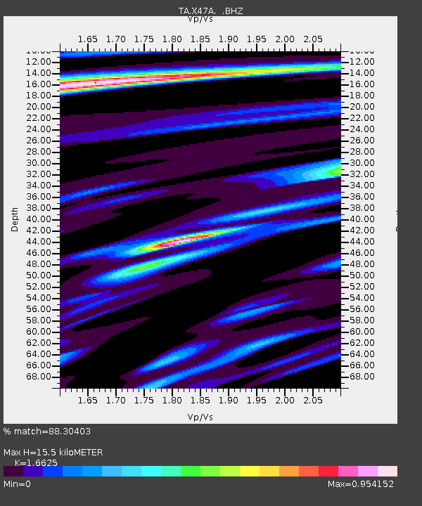
| Estimated Moho Depth: |
15.5 km |
| Estimated Crust Vp/Vs: |
1.66 |
| Assumed Crust Vp: |
6.476 km/s |
| Estimated Crust Vs: |
3.895 km/s |
| Estimated Crust Poisson's Ratio: |
0.22 |
|
| Radial Match: |
88.30403 % |
| Radial Bump: |
400 |
| Transverse Match: |
70.72355 % |
| Transverse Bump: |
400 |
| SOD ConfigId: |
469095 |
| Insert Time: |
2013-02-22 03:37:26.182 +0000 |
| GWidth: |
2.5 |
| Max Bumps: |
400 |
| Tol: |
0.001 |
|

Signal To Noise
| Channel | StoN | STA | LTA |
| TA:X47A: :BHZ:20120802T09:45:58.149988Z | 14.107591 | 9.60691E-7 | 6.809745E-8 |
| TA:X47A: :BHN:20120802T09:45:58.149988Z | 6.874759 | 4.4917857E-7 | 6.533736E-8 |
| TA:X47A: :BHE:20120802T09:45:58.149988Z | 4.0219693 | 1.6776887E-7 | 4.171312E-8 |
| Arrivals |
| Ps | 1.7 SECOND |
| PpPs | 5.9 SECOND |
| PsPs/PpSs | 7.6 SECOND |


