You are here: Home > Network List > TA - USArray Transportable Network (new EarthScope stations) Stations List
> Station X50B Fort Payne, AL, USA > Earthquake Result Viewer
X50B Fort Payne, AL, USA - Earthquake Result Viewer
| Earthquake location: |
Peru-Brazil Border Region |
| Earthquake latitude/longitude: |
-8.4/-74.3 |
| Earthquake time(UTC): |
2012/08/02 (215) 09:38:30 GMT |
| Earthquake Depth: |
145 km |
| Earthquake Magnitude: |
5.9 MB, 6.1 MW, 6.1 MW |
| Earthquake Catalog/Contributor: |
WHDF/NEIC |
|
| Network: |
TA USArray Transportable Network (new EarthScope stations) |
| Station: |
X50B Fort Payne, AL, USA |
| Lat/Lon: |
34.46 N/85.65 W |
| Elevation: |
494 m |
|
| Distance: |
44.0 deg |
| Az: |
346.409 deg |
| Baz: |
163.658 deg |
| Ray Param: |
0.07168106 |
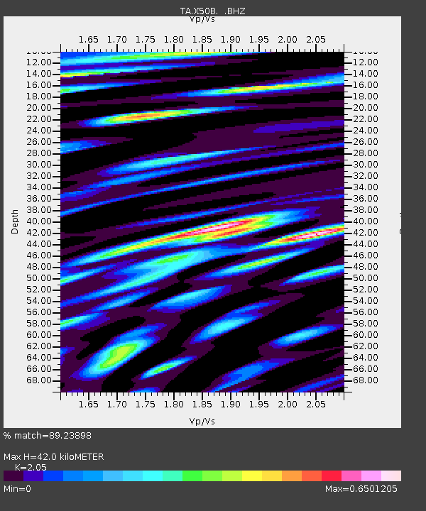
| Estimated Moho Depth: |
42.0 km |
| Estimated Crust Vp/Vs: |
2.05 |
| Assumed Crust Vp: |
6.35 km/s |
| Estimated Crust Vs: |
3.098 km/s |
| Estimated Crust Poisson's Ratio: |
0.34 |
|
| Radial Match: |
89.23898 % |
| Radial Bump: |
400 |
| Transverse Match: |
72.52012 % |
| Transverse Bump: |
400 |
| SOD ConfigId: |
469095 |
| Insert Time: |
2013-02-22 03:37:48.288 +0000 |
| GWidth: |
2.5 |
| Max Bumps: |
400 |
| Tol: |
0.001 |
|

Signal To Noise
| Channel | StoN | STA | LTA |
| TA:X50B: :BHZ:20120802T09:45:53.274988Z | 17.902096 | 1.0651607E-6 | 5.9499218E-8 |
| TA:X50B: :BHN:20120802T09:45:53.274988Z | 11.027561 | 5.9321485E-7 | 5.379384E-8 |
| TA:X50B: :BHE:20120802T09:45:53.274988Z | 4.076527 | 1.8951715E-7 | 4.6489852E-8 |
| Arrivals |
| Ps | 7.3 SECOND |
| PpPs | 19 SECOND |
| PsPs/PpSs | 26 SECOND |


