You are here: Home > Network List > TA - USArray Transportable Network (new EarthScope stations) Stations List
> Station Y48A Jasper, AL, USA > Earthquake Result Viewer
Y48A Jasper, AL, USA - Earthquake Result Viewer
| Earthquake location: |
Peru-Brazil Border Region |
| Earthquake latitude/longitude: |
-8.4/-74.3 |
| Earthquake time(UTC): |
2012/08/02 (215) 09:38:30 GMT |
| Earthquake Depth: |
145 km |
| Earthquake Magnitude: |
5.9 MB, 6.1 MW, 6.1 MW |
| Earthquake Catalog/Contributor: |
WHDF/NEIC |
|
| Network: |
TA USArray Transportable Network (new EarthScope stations) |
| Station: |
Y48A Jasper, AL, USA |
| Lat/Lon: |
33.91 N/87.17 W |
| Elevation: |
170 m |
|
| Distance: |
43.8 deg |
| Az: |
344.44 deg |
| Baz: |
161.389 deg |
| Ray Param: |
0.07176818 |
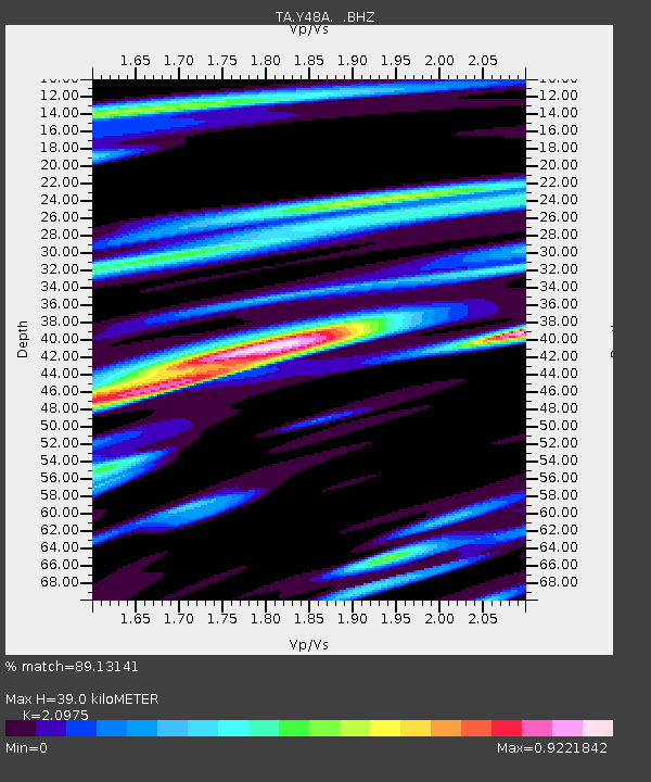
| Estimated Moho Depth: |
39.0 km |
| Estimated Crust Vp/Vs: |
2.10 |
| Assumed Crust Vp: |
6.565 km/s |
| Estimated Crust Vs: |
3.13 km/s |
| Estimated Crust Poisson's Ratio: |
0.35 |
|
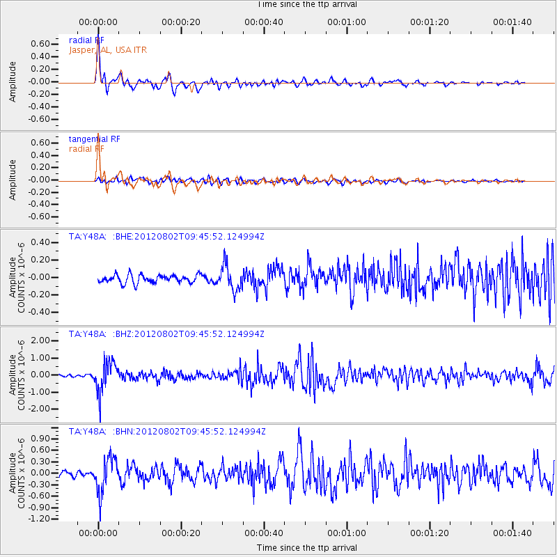
| Radial Match: |
89.13141 % |
| Radial Bump: |
400 |
| Transverse Match: |
68.15152 % |
| Transverse Bump: |
400 |
| SOD ConfigId: |
469095 |
| Insert Time: |
2013-02-22 03:37:59.277 +0000 |
| GWidth: |
2.5 |
| Max Bumps: |
400 |
| Tol: |
0.001 |
|
Signal To Noise
| Channel | StoN | STA | LTA |
| TA:Y48A: :BHZ:20120802T09:45:52.124994Z | 17.593187 | 9.146161E-7 | 5.1986948E-8 |
| TA:Y48A: :BHN:20120802T09:45:52.124994Z | 8.16932 | 4.695316E-7 | 5.7474995E-8 |
| TA:Y48A: :BHE:20120802T09:45:52.124994Z | 3.1292527 | 1.4525689E-7 | 4.6419036E-8 |
| Arrivals |
| Ps | 6.9 SECOND |
| PpPs | 17 SECOND |
| PsPs/PpSs | 24 SECOND |


