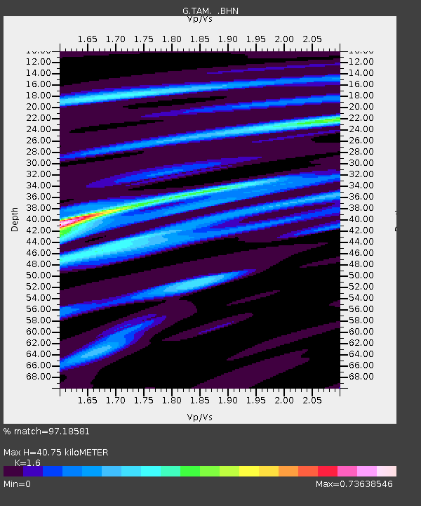
TAM Tamanrasset, Algeria - Earthquake Result Viewer
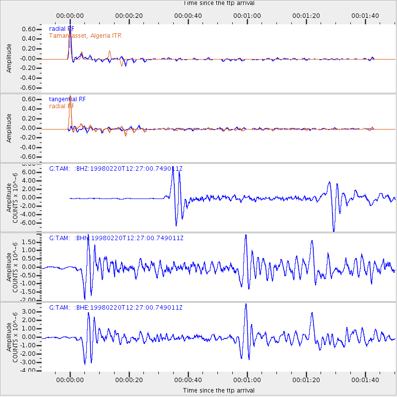
Earthquake location: Afghanistan-Tajikistan Bord Reg.
Earthquake latitude/longitude: 36.5/71.1
Earthquake time(UTC): 1998/02/20 (051) 12:18:06 GMT
Earthquake Depth: 236 km
Earthquake Magnitude: 5.8 MB, 5.7 MS, 6.4 UNKNOWN, 6.3 MW
Earthquake Catalog/Contributor: WHDF/NEIC
Network: G GEOSCOPE
Station: TAM Tamanrasset, Algeria
Lat/Lon: 22.79 N/5.53 E
Elevation: 1377 m
Distance: 57.6 deg
Az: 275.737 deg
Baz: 60.341 deg
Ray Param: 0.06258954
Estimated Moho Depth: 40.75 km
Estimated Crust Vp/Vs: 1.60
Assumed Crust Vp: 6.61 km/s
Estimated Crust Vs: 4.131 km/s
Estimated Crust Poisson's Ratio: 0.18
Radial Match: 97.18581 %
Radial Bump: 206
Transverse Match: 83.62763 %
Transverse Bump: 400
SOD ConfigId: 6273
Insert Time: 2010-02-27 00:30:25.254 +0000
GWidth: 2.5
Max Bumps: 400
Tol: 0.001

Signal To Noise

ChannelStoNSTALTA
G:TAM: :BHN:19980220T12:27:00.749011Z12.9531094.364229E-73.3692523E-8
G:TAM: :BHE:19980220T12:27:00.749011Z10.1170656.6608067E-76.583734E-8
G:TAM: :BHZ:19980220T12:27:00.749011Z31.2492581.9299248E-66.175905E-8
Arrivals
Ps3.9 SECOND
PpPs15 SECOND
PsPs/PpSs19 SECOND