You are here: Home > Network List > TA - USArray Transportable Network (new EarthScope stations) Stations List
> Station 557A Orange Park, FL, USA > Earthquake Result Viewer
557A Orange Park, FL, USA - Earthquake Result Viewer
| Earthquake location: |
Peru-Brazil Border Region |
| Earthquake latitude/longitude: |
-8.4/-74.3 |
| Earthquake time(UTC): |
2012/08/02 (215) 09:38:30 GMT |
| Earthquake Depth: |
145 km |
| Earthquake Magnitude: |
5.9 MB, 6.1 MW, 6.1 MW |
| Earthquake Catalog/Contributor: |
WHDF/NEIC |
|
| Network: |
TA USArray Transportable Network (new EarthScope stations) |
| Station: |
557A Orange Park, FL, USA |
| Lat/Lon: |
30.02 N/81.73 W |
| Elevation: |
24 m |
|
| Distance: |
38.9 deg |
| Az: |
349.65 deg |
| Baz: |
168.174 deg |
| Ray Param: |
0.07479229 |
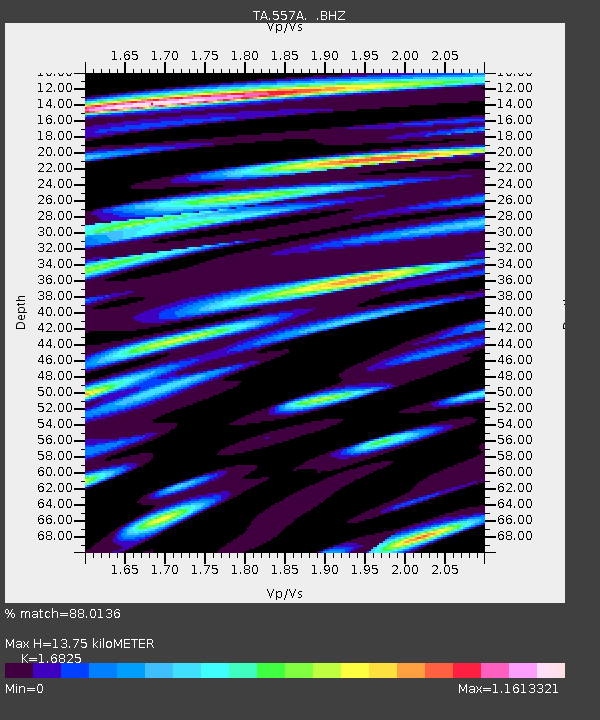
| Estimated Moho Depth: |
13.75 km |
| Estimated Crust Vp/Vs: |
1.68 |
| Assumed Crust Vp: |
5.989 km/s |
| Estimated Crust Vs: |
3.56 km/s |
| Estimated Crust Poisson's Ratio: |
0.23 |
|
| Radial Match: |
88.0136 % |
| Radial Bump: |
400 |
| Transverse Match: |
56.21289 % |
| Transverse Bump: |
400 |
| SOD ConfigId: |
469095 |
| Insert Time: |
2013-02-22 03:39:56.621 +0000 |
| GWidth: |
2.5 |
| Max Bumps: |
400 |
| Tol: |
0.001 |
|

Signal To Noise
| Channel | StoN | STA | LTA |
| TA:557A: :BHZ:20120802T09:45:11.749994Z | 5.0332756 | 1.53206E-6 | 3.0438628E-7 |
| TA:557A: :BHN:20120802T09:45:11.749994Z | 3.1206374 | 1.4417734E-6 | 4.6201248E-7 |
| TA:557A: :BHE:20120802T09:45:11.749994Z | 1.633257 | 6.297308E-7 | 3.8556746E-7 |
| Arrivals |
| Ps | 1.7 SECOND |
| PpPs | 5.8 SECOND |
| PsPs/PpSs | 7.4 SECOND |


