You are here: Home > Network List > TA - USArray Transportable Network (new EarthScope stations) Stations List
> Station 556A Lake Butler, FL, USA > Earthquake Result Viewer
556A Lake Butler, FL, USA - Earthquake Result Viewer
| Earthquake location: |
Peru-Brazil Border Region |
| Earthquake latitude/longitude: |
-8.4/-74.3 |
| Earthquake time(UTC): |
2012/08/02 (215) 09:38:30 GMT |
| Earthquake Depth: |
145 km |
| Earthquake Magnitude: |
5.9 MB, 6.1 MW, 6.1 MW |
| Earthquake Catalog/Contributor: |
WHDF/NEIC |
|
| Network: |
TA USArray Transportable Network (new EarthScope stations) |
| Station: |
556A Lake Butler, FL, USA |
| Lat/Lon: |
30.00 N/82.41 W |
| Elevation: |
45 m |
|
| Distance: |
39.0 deg |
| Az: |
348.733 deg |
| Baz: |
167.124 deg |
| Ray Param: |
0.07472494 |
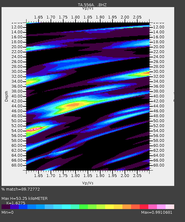
| Estimated Moho Depth: |
53.25 km |
| Estimated Crust Vp/Vs: |
1.63 |
| Assumed Crust Vp: |
6.565 km/s |
| Estimated Crust Vs: |
4.033 km/s |
| Estimated Crust Poisson's Ratio: |
0.20 |
|
| Radial Match: |
89.72772 % |
| Radial Bump: |
351 |
| Transverse Match: |
71.266266 % |
| Transverse Bump: |
400 |
| SOD ConfigId: |
469095 |
| Insert Time: |
2013-02-22 03:40:07.289 +0000 |
| GWidth: |
2.5 |
| Max Bumps: |
400 |
| Tol: |
0.001 |
|
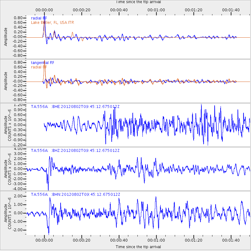
Signal To Noise
| Channel | StoN | STA | LTA |
| TA:556A: :BHZ:20120802T09:45:12.675012Z | 9.3343725 | 1.5201348E-6 | 1.6285345E-7 |
| TA:556A: :BHN:20120802T09:45:12.675012Z | 9.944902 | 1.0107354E-6 | 1.0163352E-7 |
| TA:556A: :BHE:20120802T09:45:12.675012Z | 1.9086719 | 3.814523E-7 | 1.9985221E-7 |
| Arrivals |
| Ps | 5.5 SECOND |
| PpPs | 20 SECOND |
| PsPs/PpSs | 25 SECOND |


