You are here: Home > Network List > TA - USArray Transportable Network (new EarthScope stations) Stations List
> Station 553A Crawfordville, FL, USA > Earthquake Result Viewer
553A Crawfordville, FL, USA - Earthquake Result Viewer
| Earthquake location: |
Peru-Brazil Border Region |
| Earthquake latitude/longitude: |
-8.4/-74.3 |
| Earthquake time(UTC): |
2012/08/02 (215) 09:38:30 GMT |
| Earthquake Depth: |
145 km |
| Earthquake Magnitude: |
5.9 MB, 6.1 MW, 6.1 MW |
| Earthquake Catalog/Contributor: |
WHDF/NEIC |
|
| Network: |
TA USArray Transportable Network (new EarthScope stations) |
| Station: |
553A Crawfordville, FL, USA |
| Lat/Lon: |
30.19 N/84.43 W |
| Elevation: |
16 m |
|
| Distance: |
39.6 deg |
| Az: |
346.121 deg |
| Baz: |
164.092 deg |
| Ray Param: |
0.07437187 |
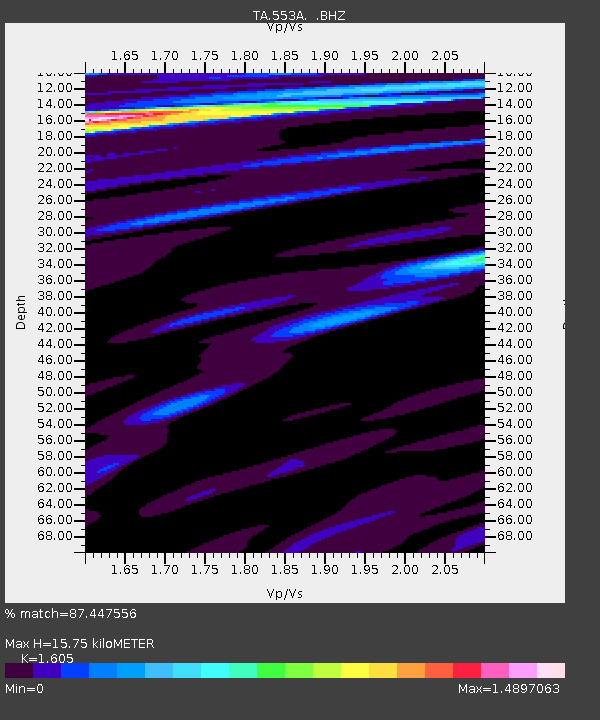
| Estimated Moho Depth: |
15.75 km |
| Estimated Crust Vp/Vs: |
1.61 |
| Assumed Crust Vp: |
6.347 km/s |
| Estimated Crust Vs: |
3.955 km/s |
| Estimated Crust Poisson's Ratio: |
0.18 |
|
| Radial Match: |
87.447556 % |
| Radial Bump: |
400 |
| Transverse Match: |
78.981575 % |
| Transverse Bump: |
400 |
| SOD ConfigId: |
469095 |
| Insert Time: |
2013-02-22 03:40:19.022 +0000 |
| GWidth: |
2.5 |
| Max Bumps: |
400 |
| Tol: |
0.001 |
|

Signal To Noise
| Channel | StoN | STA | LTA |
| TA:553A: :BHZ:20120802T09:45:17.774988Z | 22.425278 | 3.426767E-6 | 1.5280823E-7 |
| TA:553A: :BHN:20120802T09:45:17.774988Z | 10.37877 | 1.4050748E-6 | 1.3537971E-7 |
| TA:553A: :BHE:20120802T09:45:17.774988Z | 2.8576336 | 5.7996897E-7 | 2.0295428E-7 |
| Arrivals |
| Ps | 1.6 SECOND |
| PpPs | 6.0 SECOND |
| PsPs/PpSs | 7.6 SECOND |


