You are here: Home > Network List > TA - USArray Transportable Network (new EarthScope stations) Stations List
> Station 453A Whigham, GA, USA > Earthquake Result Viewer
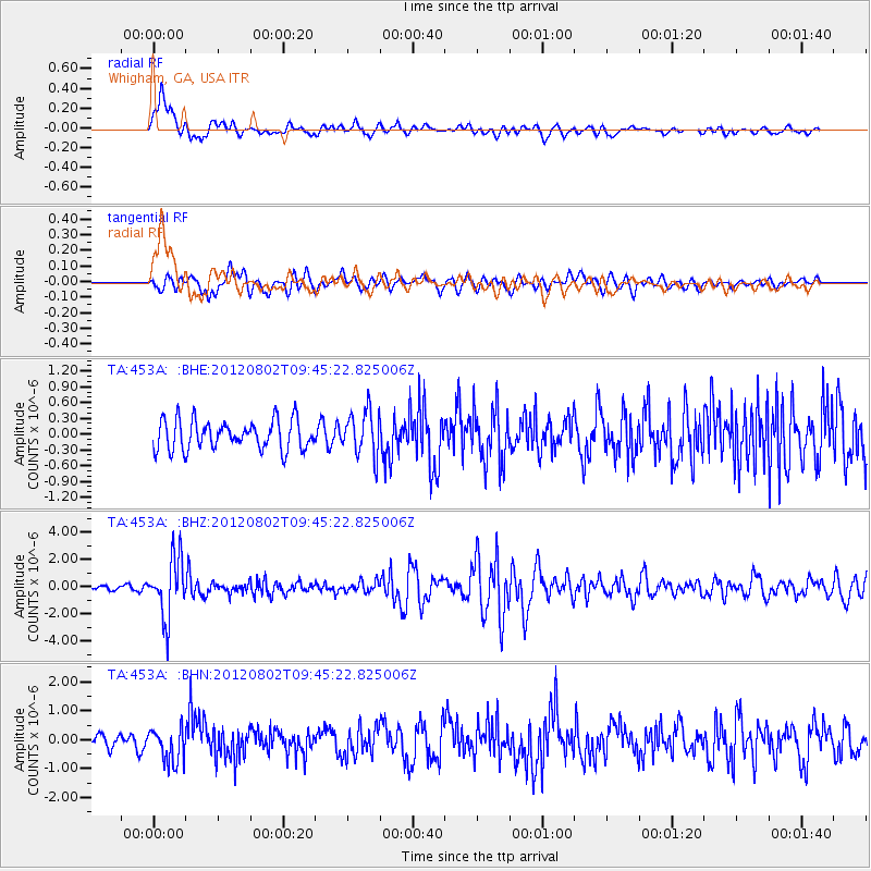
453A Whigham, GA, USA - Earthquake Result Viewer
*The percent match for this event was below the threshold and hence no stack was calculated.
| Earthquake location: |
Peru-Brazil Border Region |
| Earthquake latitude/longitude: |
-8.4/-74.3 |
| Earthquake time(UTC): |
2012/08/02 (215) 09:38:30 GMT |
| Earthquake Depth: |
145 km |
| Earthquake Magnitude: |
5.9 MB, 6.1 MW, 6.1 MW |
| Earthquake Catalog/Contributor: |
WHDF/NEIC |
|
| Network: |
TA USArray Transportable Network (new EarthScope stations) |
| Station: |
453A Whigham, GA, USA |
| Lat/Lon: |
30.85 N/84.32 W |
| Elevation: |
82 m |
|
| Distance: |
40.2 deg |
| Az: |
346.546 deg |
| Baz: |
164.474 deg |
| Ray Param: |
$rayparam |
*The percent match for this event was below the threshold and hence was not used in the summary stack. |
|
| Radial Match: |
85.5076 % |
| Radial Bump: |
400 |
| Transverse Match: |
68.41263 % |
| Transverse Bump: |
400 |
| SOD ConfigId: |
469095 |
| Insert Time: |
2013-02-22 03:40:31.168 +0000 |
| GWidth: |
2.5 |
| Max Bumps: |
400 |
| Tol: |
0.001 |
|
Signal To Noise
| Channel | StoN | STA | LTA |
| TA:453A: :BHZ:20120802T09:45:22.825006Z | 11.91399 | 2.1676199E-6 | 1.8193904E-7 |
| TA:453A: :BHN:20120802T09:45:22.825006Z | 2.5311255 | 5.9893574E-7 | 2.3662824E-7 |
| TA:453A: :BHE:20120802T09:45:22.825006Z | 1.5418695 | 4.2463932E-7 | 2.7540548E-7 |
| Arrivals |
| Ps | |
| PpPs | |
| PsPs/PpSs | |


