You are here: Home > Network List > TA - USArray Transportable Network (new EarthScope stations) Stations List
> Station 655A Horseshoe Beach, FL, USA > Earthquake Result Viewer
655A Horseshoe Beach, FL, USA - Earthquake Result Viewer
| Earthquake location: |
Peru-Brazil Border Region |
| Earthquake latitude/longitude: |
-8.4/-74.3 |
| Earthquake time(UTC): |
2012/08/02 (215) 09:38:30 GMT |
| Earthquake Depth: |
145 km |
| Earthquake Magnitude: |
5.9 MB, 6.1 MW, 6.1 MW |
| Earthquake Catalog/Contributor: |
WHDF/NEIC |
|
| Network: |
TA USArray Transportable Network (new EarthScope stations) |
| Station: |
655A Horseshoe Beach, FL, USA |
| Lat/Lon: |
29.51 N/83.26 W |
| Elevation: |
6.0 m |
|
| Distance: |
38.7 deg |
| Az: |
347.405 deg |
| Baz: |
165.67 deg |
| Ray Param: |
0.074901894 |
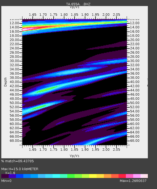
| Estimated Moho Depth: |
15.0 km |
| Estimated Crust Vp/Vs: |
1.60 |
| Assumed Crust Vp: |
5.989 km/s |
| Estimated Crust Vs: |
3.743 km/s |
| Estimated Crust Poisson's Ratio: |
0.18 |
|
| Radial Match: |
89.43785 % |
| Radial Bump: |
375 |
| Transverse Match: |
76.907234 % |
| Transverse Bump: |
400 |
| SOD ConfigId: |
469095 |
| Insert Time: |
2013-02-22 03:41:06.508 +0000 |
| GWidth: |
2.5 |
| Max Bumps: |
400 |
| Tol: |
0.001 |
|
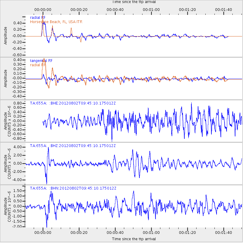
Signal To Noise
| Channel | StoN | STA | LTA |
| TA:655A: :BHZ:20120802T09:45:10.175012Z | 10.6142025 | 1.8558188E-6 | 1.7484298E-7 |
| TA:655A: :BHN:20120802T09:45:10.175012Z | 6.762635 | 8.1455397E-7 | 1.2044919E-7 |
| TA:655A: :BHE:20120802T09:45:10.175012Z | 1.8986784 | 2.7268436E-7 | 1.4361798E-7 |
| Arrivals |
| Ps | 1.6 SECOND |
| PpPs | 6.1 SECOND |
| PsPs/PpSs | 7.7 SECOND |


