You are here: Home > Network List > TA - USArray Transportable Network (new EarthScope stations) Stations List
> Station 656A Willston, FL, USA > Earthquake Result Viewer
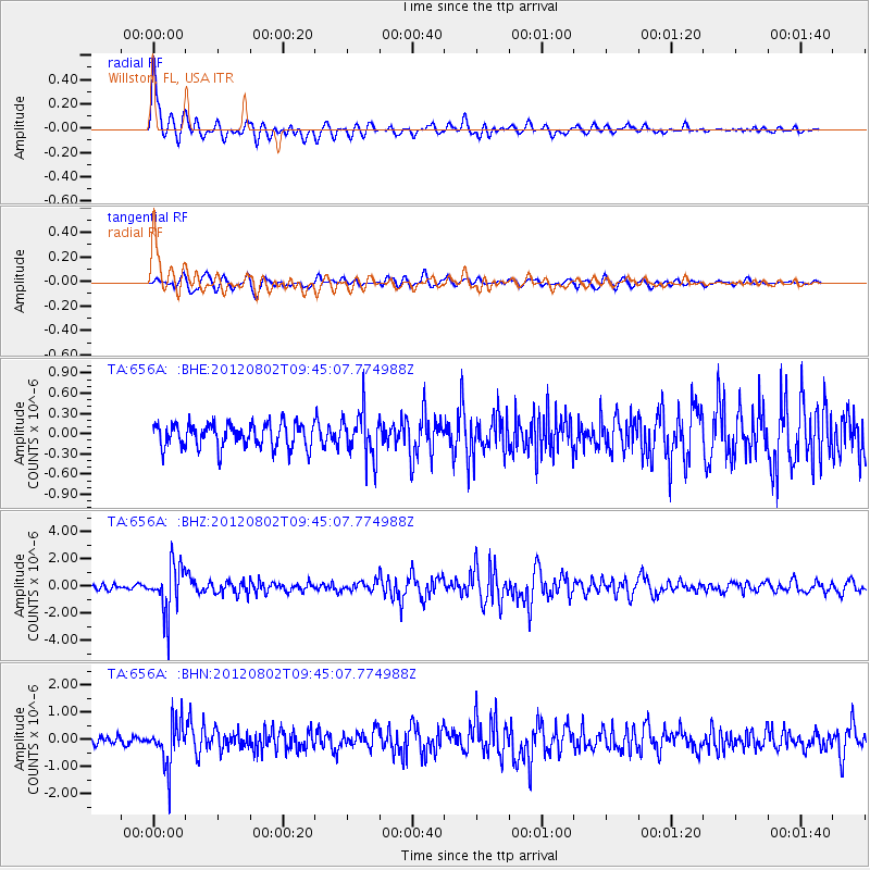
656A Willston, FL, USA - Earthquake Result Viewer

| Earthquake location: |
Peru-Brazil Border Region |
| Earthquake latitude/longitude: |
-8.4/-74.3 |
| Earthquake time(UTC): |
2012/08/02 (215) 09:38:30 GMT |
| Earthquake Depth: |
145 km |
| Earthquake Magnitude: |
5.9 MB, 6.1 MW, 6.1 MW |
| Earthquake Catalog/Contributor: |
WHDF/NEIC |
|
| Network: |
TA USArray Transportable Network (new EarthScope stations) |
| Station: |
656A Willston, FL, USA |
| Lat/Lon: |
29.37 N/82.53 W |
| Elevation: |
28 m |
|
| Distance: |
38.4 deg |
| Az: |
348.33 deg |
| Baz: |
166.746 deg |
| Ray Param: |
0.07506592 |
| Estimated Moho Depth: |
32.0 km |
| Estimated Crust Vp/Vs: |
1.88 |
| Assumed Crust Vp: |
5.989 km/s |
| Estimated Crust Vs: |
3.186 km/s |
| Estimated Crust Poisson's Ratio: |
0.30 |
|
| Radial Match: |
87.9588 % |
| Radial Bump: |
400 |
| Transverse Match: |
71.70374 % |
| Transverse Bump: |
400 |
| SOD ConfigId: |
469095 |
| Insert Time: |
2013-02-22 03:41:18.397 +0000 |
| GWidth: |
2.5 |
| Max Bumps: |
400 |
| Tol: |
0.001 |
|
Signal To Noise
| Channel | StoN | STA | LTA |
| TA:656A: :BHZ:20120802T09:45:07.774988Z | 9.7896385 | 1.7860627E-6 | 1.824442E-7 |
| TA:656A: :BHN:20120802T09:45:07.774988Z | 6.2858124 | 7.946453E-7 | 1.2641887E-7 |
| TA:656A: :BHE:20120802T09:45:07.774988Z | 1.9099102 | 3.4245423E-7 | 1.7930384E-7 |
| Arrivals |
| Ps | 5.0 SECOND |
| PpPs | 15 SECOND |
| PsPs/PpSs | 20 SECOND |


