You are here: Home > Network List > TA - USArray Transportable Network (new EarthScope stations) Stations List
> Station 958A Wauchula, FL, USA > Earthquake Result Viewer
958A Wauchula, FL, USA - Earthquake Result Viewer
| Earthquake location: |
Peru-Brazil Border Region |
| Earthquake latitude/longitude: |
-8.4/-74.3 |
| Earthquake time(UTC): |
2012/08/02 (215) 09:38:30 GMT |
| Earthquake Depth: |
145 km |
| Earthquake Magnitude: |
5.9 MB, 6.1 MW, 6.1 MW |
| Earthquake Catalog/Contributor: |
WHDF/NEIC |
|
| Network: |
TA USArray Transportable Network (new EarthScope stations) |
| Station: |
958A Wauchula, FL, USA |
| Lat/Lon: |
27.59 N/81.75 W |
| Elevation: |
30 m |
|
| Distance: |
36.5 deg |
| Az: |
348.78 deg |
| Baz: |
167.473 deg |
| Ray Param: |
0.07613941 |
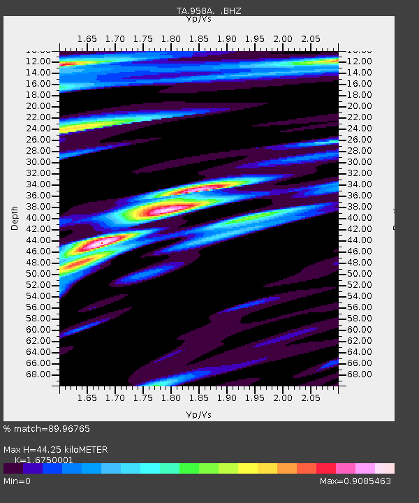
| Estimated Moho Depth: |
44.25 km |
| Estimated Crust Vp/Vs: |
1.68 |
| Assumed Crust Vp: |
6.347 km/s |
| Estimated Crust Vs: |
3.789 km/s |
| Estimated Crust Poisson's Ratio: |
0.22 |
|
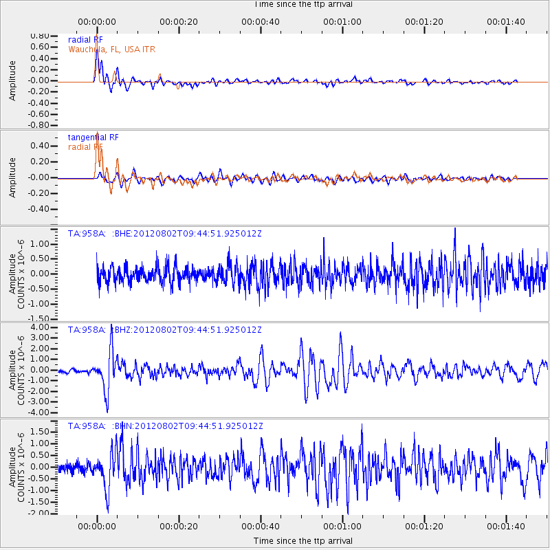
| Radial Match: |
89.96765 % |
| Radial Bump: |
400 |
| Transverse Match: |
72.28509 % |
| Transverse Bump: |
400 |
| SOD ConfigId: |
469095 |
| Insert Time: |
2013-02-22 03:41:41.720 +0000 |
| GWidth: |
2.5 |
| Max Bumps: |
400 |
| Tol: |
0.001 |
|
Signal To Noise
| Channel | StoN | STA | LTA |
| TA:958A: :BHZ:20120802T09:44:51.925012Z | 12.854363 | 1.887048E-6 | 1.4680214E-7 |
| TA:958A: :BHN:20120802T09:44:51.925012Z | 4.1548843 | 7.980426E-7 | 1.9207337E-7 |
| TA:958A: :BHE:20120802T09:44:51.925012Z | 1.2980249 | 3.2965679E-7 | 2.5396798E-7 |
| Arrivals |
| Ps | 5.1 SECOND |
| PpPs | 17 SECOND |
| PsPs/PpSs | 22 SECOND |


