You are here: Home > Network List > TA - USArray Transportable Network (new EarthScope stations) Stations List
> Station 059Z Ave Maria, FL, USA > Earthquake Result Viewer
059Z Ave Maria, FL, USA - Earthquake Result Viewer
| Earthquake location: |
Peru-Brazil Border Region |
| Earthquake latitude/longitude: |
-8.4/-74.3 |
| Earthquake time(UTC): |
2012/08/02 (215) 09:38:30 GMT |
| Earthquake Depth: |
145 km |
| Earthquake Magnitude: |
5.9 MB, 6.1 MW, 6.1 MW |
| Earthquake Catalog/Contributor: |
WHDF/NEIC |
|
| Network: |
TA USArray Transportable Network (new EarthScope stations) |
| Station: |
059Z Ave Maria, FL, USA |
| Lat/Lon: |
26.34 N/81.44 W |
| Elevation: |
8.0 m |
|
| Distance: |
35.2 deg |
| Az: |
348.785 deg |
| Baz: |
167.618 deg |
| Ray Param: |
0.07682615 |
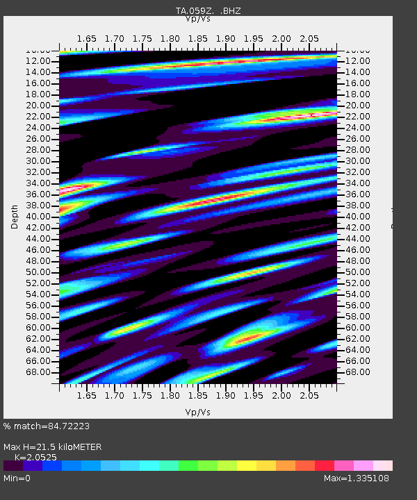
| Estimated Moho Depth: |
21.5 km |
| Estimated Crust Vp/Vs: |
2.05 |
| Assumed Crust Vp: |
6.347 km/s |
| Estimated Crust Vs: |
3.092 km/s |
| Estimated Crust Poisson's Ratio: |
0.34 |
|
| Radial Match: |
84.72223 % |
| Radial Bump: |
400 |
| Transverse Match: |
69.552605 % |
| Transverse Bump: |
400 |
| SOD ConfigId: |
469095 |
| Insert Time: |
2013-02-22 03:42:27.447 +0000 |
| GWidth: |
2.5 |
| Max Bumps: |
400 |
| Tol: |
0.001 |
|
Signal To Noise
| Channel | StoN | STA | LTA |
| TA:059Z: :BHZ:20120802T09:44:41.100Z | 13.62234 | 2.2970503E-6 | 1.6862377E-7 |
| TA:059Z: :BHN:20120802T09:44:41.100Z | 5.8923573 | 1.6207184E-6 | 2.7505433E-7 |
| TA:059Z: :BHE:20120802T09:44:41.100Z | 1.8788034 | 4.0483582E-7 | 2.1547534E-7 |
| Arrivals |
| Ps | 3.8 SECOND |
| PpPs | 9.7 SECOND |
| PsPs/PpSs | 14 SECOND |


