You are here: Home > Network List > TA - USArray Transportable Network (new EarthScope stations) Stations List
> Station 153A Fort Valley, GA, USA > Earthquake Result Viewer
153A Fort Valley, GA, USA - Earthquake Result Viewer

| Earthquake location: |
Peru-Brazil Border Region |
| Earthquake latitude/longitude: |
-8.4/-74.3 |
| Earthquake time(UTC): |
2012/08/02 (215) 09:38:30 GMT |
| Earthquake Depth: |
145 km |
| Earthquake Magnitude: |
5.9 MB, 6.1 MW, 6.1 MW |
| Earthquake Catalog/Contributor: |
WHDF/NEIC |
|
| Network: |
TA USArray Transportable Network (new EarthScope stations) |
| Station: |
153A Fort Valley, GA, USA |
| Lat/Lon: |
32.66 N/83.83 W |
| Elevation: |
160 m |
|
| Distance: |
41.9 deg |
| Az: |
347.863 deg |
| Baz: |
165.724 deg |
| Ray Param: |
0.07301386 |
| Estimated Moho Depth: |
13.25 km |
| Estimated Crust Vp/Vs: |
1.62 |
| Assumed Crust Vp: |
6.565 km/s |
| Estimated Crust Vs: |
4.065 km/s |
| Estimated Crust Poisson's Ratio: |
0.19 |
|
| Radial Match: |
93.82509 % |
| Radial Bump: |
400 |
| Transverse Match: |
89.29906 % |
| Transverse Bump: |
400 |
| SOD ConfigId: |
469095 |
| Insert Time: |
2013-02-22 03:43:14.252 +0000 |
| GWidth: |
2.5 |
| Max Bumps: |
400 |
| Tol: |
0.001 |
|
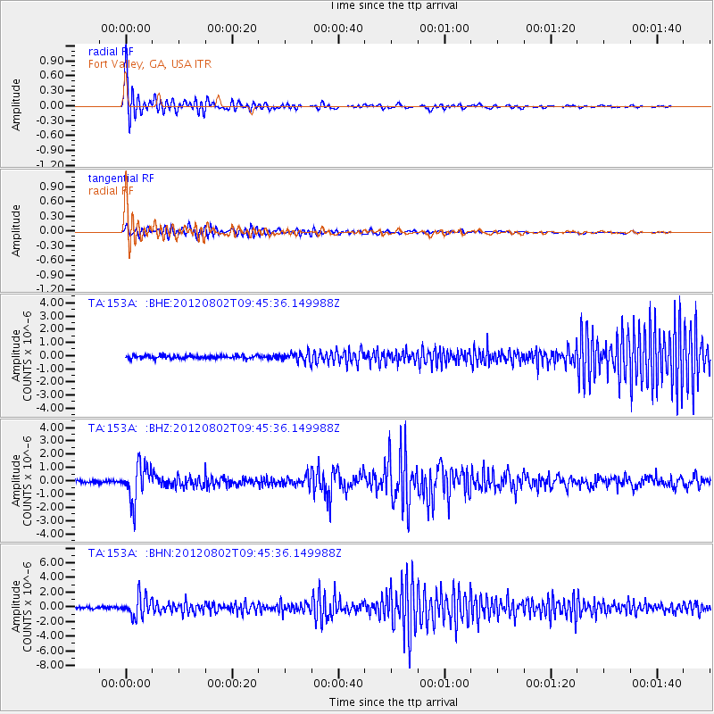
Signal To Noise
| Channel | StoN | STA | LTA |
| TA:153A: :BHZ:20120802T09:45:36.149988Z | 15.41149 | 1.3669525E-6 | 8.869697E-8 |
| TA:153A: :BHN:20120802T09:45:36.149988Z | 12.269264 | 1.4142624E-6 | 1.15268726E-7 |
| TA:153A: :BHE:20120802T09:45:36.149988Z | 2.8208475 | 3.466802E-7 | 1.228993E-7 |
| Arrivals |
| Ps | 1.3 SECOND |
| PpPs | 4.9 SECOND |
| PsPs/PpSs | 6.2 SECOND |


