You are here: Home > Network List > TA - USArray Transportable Network (new EarthScope stations) Stations List
> Station 152A Waverly Hall, GA, USA > Earthquake Result Viewer
152A Waverly Hall, GA, USA - Earthquake Result Viewer
| Earthquake location: |
Peru-Brazil Border Region |
| Earthquake latitude/longitude: |
-8.4/-74.3 |
| Earthquake time(UTC): |
2012/08/02 (215) 09:38:30 GMT |
| Earthquake Depth: |
145 km |
| Earthquake Magnitude: |
5.9 MB, 6.1 MW, 6.1 MW |
| Earthquake Catalog/Contributor: |
WHDF/NEIC |
|
| Network: |
TA USArray Transportable Network (new EarthScope stations) |
| Station: |
152A Waverly Hall, GA, USA |
| Lat/Lon: |
32.67 N/84.72 W |
| Elevation: |
214 m |
|
| Distance: |
42.1 deg |
| Az: |
346.785 deg |
| Baz: |
164.445 deg |
| Ray Param: |
0.07288933 |
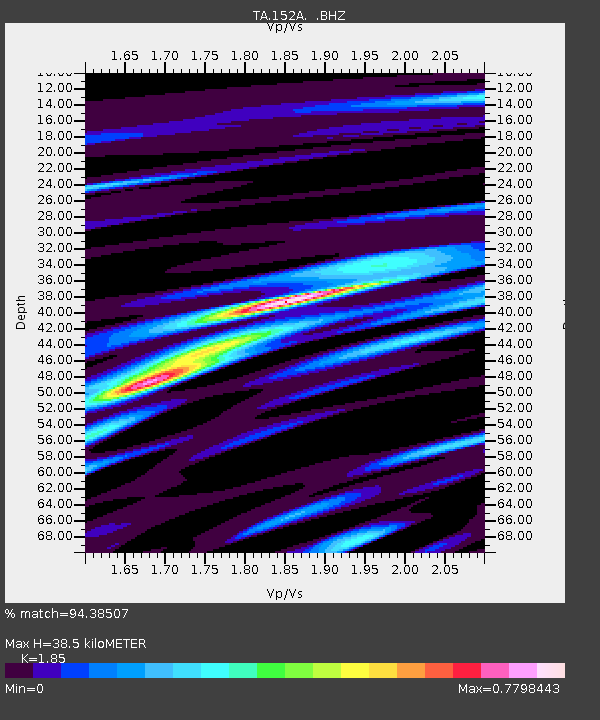
| Estimated Moho Depth: |
38.5 km |
| Estimated Crust Vp/Vs: |
1.85 |
| Assumed Crust Vp: |
6.719 km/s |
| Estimated Crust Vs: |
3.632 km/s |
| Estimated Crust Poisson's Ratio: |
0.29 |
|
| Radial Match: |
94.38507 % |
| Radial Bump: |
289 |
| Transverse Match: |
86.03269 % |
| Transverse Bump: |
400 |
| SOD ConfigId: |
469095 |
| Insert Time: |
2013-02-22 03:43:26.350 +0000 |
| GWidth: |
2.5 |
| Max Bumps: |
400 |
| Tol: |
0.001 |
|

Signal To Noise
| Channel | StoN | STA | LTA |
| TA:152A: :BHZ:20120802T09:45:37.774988Z | 18.340708 | 1.1212254E-6 | 6.113316E-8 |
| TA:152A: :BHN:20120802T09:45:37.774988Z | 12.129761 | 7.213235E-7 | 5.9467244E-8 |
| TA:152A: :BHE:20120802T09:45:37.774988Z | 4.7201667 | 2.5177096E-7 | 5.333942E-8 |
| Arrivals |
| Ps | 5.2 SECOND |
| PpPs | 15 SECOND |
| PsPs/PpSs | 20 SECOND |


