You are here: Home > Network List > TA - USArray Transportable Network (new EarthScope stations) Stations List
> Station Y51A Rockmart, GA, USA > Earthquake Result Viewer
Y51A Rockmart, GA, USA - Earthquake Result Viewer
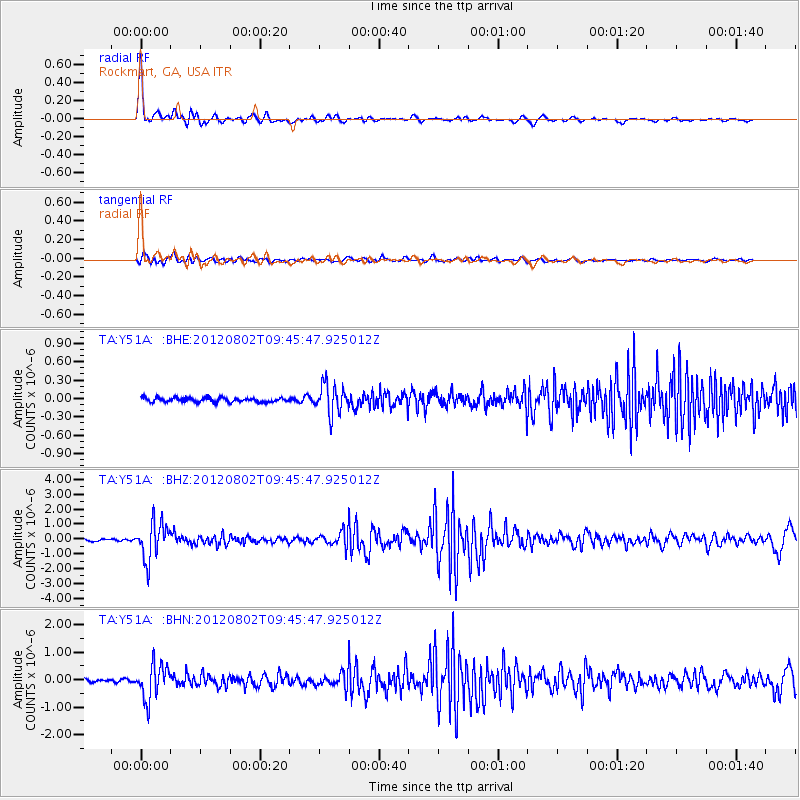
| Earthquake location: |
Peru-Brazil Border Region |
| Earthquake latitude/longitude: |
-8.4/-74.3 |
| Earthquake time(UTC): |
2012/08/02 (215) 09:38:30 GMT |
| Earthquake Depth: |
145 km |
| Earthquake Magnitude: |
5.9 MB, 6.1 MW, 6.1 MW |
| Earthquake Catalog/Contributor: |
WHDF/NEIC |
|
| Network: |
TA USArray Transportable Network (new EarthScope stations) |
| Station: |
Y51A Rockmart, GA, USA |
| Lat/Lon: |
33.90 N/85.06 W |
| Elevation: |
380 m |
|
| Distance: |
43.3 deg |
| Az: |
346.862 deg |
| Baz: |
164.313 deg |
| Ray Param: |
0.07209069 |
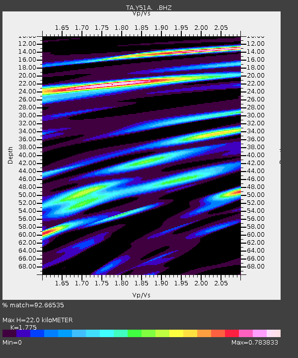
| Estimated Moho Depth: |
22.0 km |
| Estimated Crust Vp/Vs: |
1.77 |
| Assumed Crust Vp: |
6.719 km/s |
| Estimated Crust Vs: |
3.786 km/s |
| Estimated Crust Poisson's Ratio: |
0.27 |
|
| Radial Match: |
92.66535 % |
| Radial Bump: |
283 |
| Transverse Match: |
76.56084 % |
| Transverse Bump: |
400 |
| SOD ConfigId: |
469095 |
| Insert Time: |
2013-02-22 03:43:59.148 +0000 |
| GWidth: |
2.5 |
| Max Bumps: |
400 |
| Tol: |
0.001 |
|
Signal To Noise
| Channel | StoN | STA | LTA |
| TA:Y51A: :BHZ:20120802T09:45:47.925012Z | 21.521423 | 1.2271521E-6 | 5.7020028E-8 |
| TA:Y51A: :BHN:20120802T09:45:47.925012Z | 10.424351 | 6.1501265E-7 | 5.8997696E-8 |
| TA:Y51A: :BHE:20120802T09:45:47.925012Z | 6.6726804 | 2.3392931E-7 | 3.5057774E-8 |
| Arrivals |
| Ps | 2.7 SECOND |
| PpPs | 8.5 SECOND |
| PsPs/PpSs | 11 SECOND |


