You are here: Home > Network List > TA - USArray Transportable Network (new EarthScope stations) Stations List
> Station V49A McMinnville, TN, USA > Earthquake Result Viewer
V49A McMinnville, TN, USA - Earthquake Result Viewer
| Earthquake location: |
Peru-Brazil Border Region |
| Earthquake latitude/longitude: |
-8.4/-74.3 |
| Earthquake time(UTC): |
2012/08/02 (215) 09:38:30 GMT |
| Earthquake Depth: |
145 km |
| Earthquake Magnitude: |
5.9 MB, 6.1 MW, 6.1 MW |
| Earthquake Catalog/Contributor: |
WHDF/NEIC |
|
| Network: |
TA USArray Transportable Network (new EarthScope stations) |
| Station: |
V49A McMinnville, TN, USA |
| Lat/Lon: |
35.77 N/85.90 W |
| Elevation: |
329 m |
|
| Distance: |
45.3 deg |
| Az: |
346.647 deg |
| Baz: |
163.682 deg |
| Ray Param: |
0.070844844 |
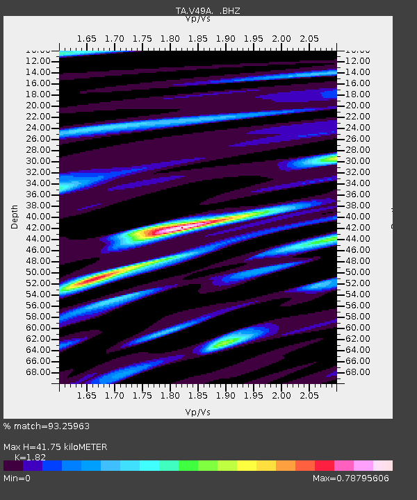
| Estimated Moho Depth: |
41.75 km |
| Estimated Crust Vp/Vs: |
1.82 |
| Assumed Crust Vp: |
6.35 km/s |
| Estimated Crust Vs: |
3.489 km/s |
| Estimated Crust Poisson's Ratio: |
0.28 |
|
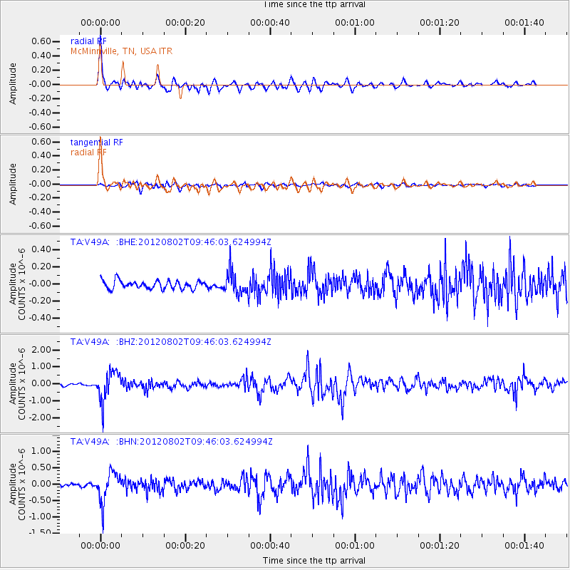
| Radial Match: |
93.25963 % |
| Radial Bump: |
400 |
| Transverse Match: |
77.914986 % |
| Transverse Bump: |
400 |
| SOD ConfigId: |
469095 |
| Insert Time: |
2013-02-22 03:45:09.339 +0000 |
| GWidth: |
2.5 |
| Max Bumps: |
400 |
| Tol: |
0.001 |
|
Signal To Noise
| Channel | StoN | STA | LTA |
| TA:V49A: :BHZ:20120802T09:46:03.624994Z | 15.313154 | 8.9060484E-7 | 5.8159465E-8 |
| TA:V49A: :BHN:20120802T09:46:03.624994Z | 9.221548 | 4.6766166E-7 | 5.071401E-8 |
| TA:V49A: :BHE:20120802T09:46:03.624994Z | 2.802854 | 1.3236645E-7 | 4.7225594E-8 |
| Arrivals |
| Ps | 5.7 SECOND |
| PpPs | 17 SECOND |
| PsPs/PpSs | 23 SECOND |


