You are here: Home > Network List > TA - USArray Transportable Network (new EarthScope stations) Stations List
> Station 060Z West Palm Beach, FL, USA > Earthquake Result Viewer
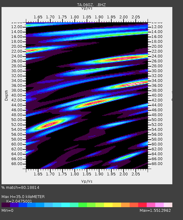
060Z West Palm Beach, FL, USA - Earthquake Result Viewer
| Earthquake location: |
Peru-Brazil Border Region |
| Earthquake latitude/longitude: |
-8.4/-74.3 |
| Earthquake time(UTC): |
2012/08/02 (215) 09:38:30 GMT |
| Earthquake Depth: |
145 km |
| Earthquake Magnitude: |
5.9 MB, 6.1 MW, 6.1 MW |
| Earthquake Catalog/Contributor: |
WHDF/NEIC |
|
| Network: |
TA USArray Transportable Network (new EarthScope stations) |
| Station: |
060Z West Palm Beach, FL, USA |
| Lat/Lon: |
26.41 N/80.56 W |
| Elevation: |
9.0 m |
|
| Distance: |
35.1 deg |
| Az: |
350.162 deg |
| Baz: |
169.135 deg |
| Ray Param: |
0.076876365 |
| Estimated Moho Depth: |
35.0 km |
| Estimated Crust Vp/Vs: |
2.05 |
| Assumed Crust Vp: |
6.347 km/s |
| Estimated Crust Vs: |
3.1 km/s |
| Estimated Crust Poisson's Ratio: |
0.34 |
|
| Radial Match: |
80.18814 % |
| Radial Bump: |
400 |
| Transverse Match: |
58.470432 % |
| Transverse Bump: |
400 |
| SOD ConfigId: |
469095 |
| Insert Time: |
2013-02-22 03:45:29.633 +0000 |
| GWidth: |
2.5 |
| Max Bumps: |
400 |
| Tol: |
0.001 |
|

Signal To Noise
| Channel | StoN | STA | LTA |
| TA:060Z: :BHZ:20120802T09:44:40.325006Z | 10.550122 | 2.0802834E-6 | 1.9718098E-7 |
| TA:060Z: :BHN:20120802T09:44:40.325006Z | 3.2802367 | 9.4683077E-7 | 2.8864707E-7 |
| TA:060Z: :BHE:20120802T09:44:40.325006Z | 1.129612 | 2.9687848E-7 | 2.6281455E-7 |
| Arrivals |
| Ps | 6.2 SECOND |
| PpPs | 16 SECOND |
| PsPs/PpSs | 22 SECOND |


