You are here: Home > Network List > TA - USArray Transportable Network (new EarthScope stations) Stations List
> Station 061Z Ochoppi, FL, USA > Earthquake Result Viewer
061Z Ochoppi, FL, USA - Earthquake Result Viewer
| Earthquake location: |
Peru-Brazil Border Region |
| Earthquake latitude/longitude: |
-8.4/-74.3 |
| Earthquake time(UTC): |
2012/08/02 (215) 09:38:30 GMT |
| Earthquake Depth: |
145 km |
| Earthquake Magnitude: |
5.9 MB, 6.1 MW, 6.1 MW |
| Earthquake Catalog/Contributor: |
WHDF/NEIC |
|
| Network: |
TA USArray Transportable Network (new EarthScope stations) |
| Station: |
061Z Ochoppi, FL, USA |
| Lat/Lon: |
25.87 N/80.91 W |
| Elevation: |
9.0 m |
|
| Distance: |
34.7 deg |
| Az: |
349.438 deg |
| Baz: |
168.387 deg |
| Ray Param: |
0.07712697 |
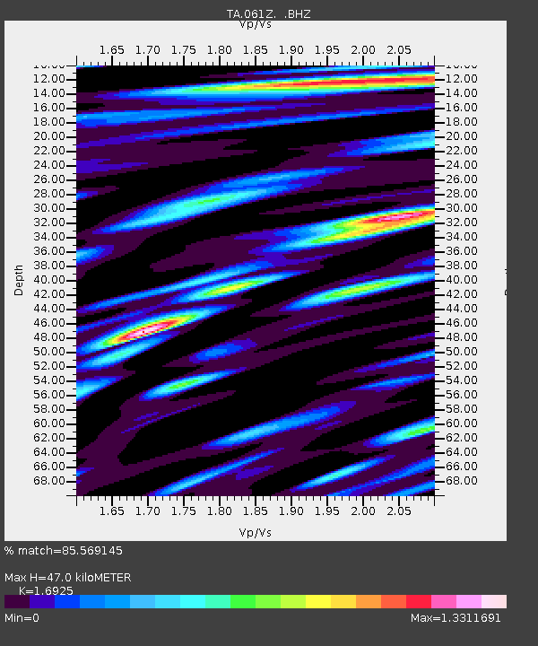
| Estimated Moho Depth: |
47.0 km |
| Estimated Crust Vp/Vs: |
1.69 |
| Assumed Crust Vp: |
5.78 km/s |
| Estimated Crust Vs: |
3.415 km/s |
| Estimated Crust Poisson's Ratio: |
0.23 |
|
| Radial Match: |
85.569145 % |
| Radial Bump: |
400 |
| Transverse Match: |
55.519657 % |
| Transverse Bump: |
400 |
| SOD ConfigId: |
469095 |
| Insert Time: |
2013-02-22 03:45:33.459 +0000 |
| GWidth: |
2.5 |
| Max Bumps: |
400 |
| Tol: |
0.001 |
|
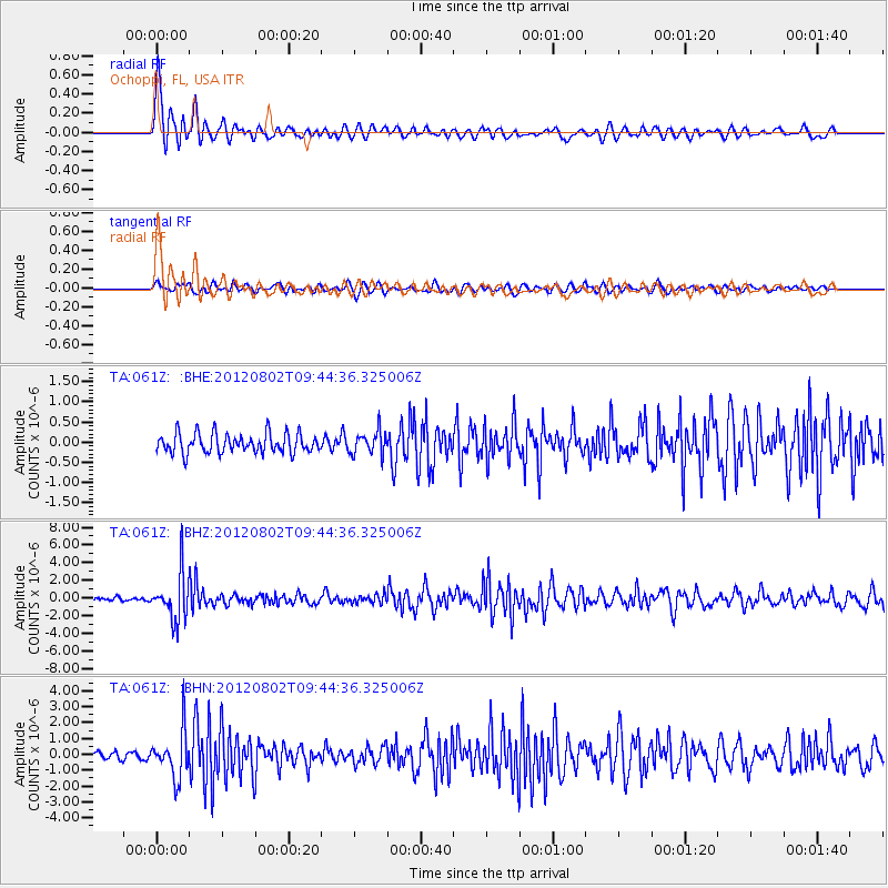
Signal To Noise
| Channel | StoN | STA | LTA |
| TA:061Z: :BHZ:20120802T09:44:36.325006Z | 16.160177 | 2.637307E-6 | 1.631979E-7 |
| TA:061Z: :BHN:20120802T09:44:36.325006Z | 6.301442 | 1.4534957E-6 | 2.3066079E-7 |
| TA:061Z: :BHE:20120802T09:44:36.325006Z | 1.1882455 | 2.8485834E-7 | 2.3973018E-7 |
| Arrivals |
| Ps | 6.0 SECOND |
| PpPs | 21 SECOND |
| PsPs/PpSs | 27 SECOND |


