You are here: Home > Network List > TA - USArray Transportable Network (new EarthScope stations) Stations List
> Station T52A Hallie, KY, USA > Earthquake Result Viewer
T52A Hallie, KY, USA - Earthquake Result Viewer
| Earthquake location: |
Peru-Brazil Border Region |
| Earthquake latitude/longitude: |
-8.4/-74.3 |
| Earthquake time(UTC): |
2012/08/02 (215) 09:38:30 GMT |
| Earthquake Depth: |
145 km |
| Earthquake Magnitude: |
5.9 MB, 6.1 MW, 6.1 MW |
| Earthquake Catalog/Contributor: |
WHDF/NEIC |
|
| Network: |
TA USArray Transportable Network (new EarthScope stations) |
| Station: |
T52A Hallie, KY, USA |
| Lat/Lon: |
37.11 N/82.99 W |
| Elevation: |
436 m |
|
| Distance: |
46.0 deg |
| Az: |
350.296 deg |
| Baz: |
167.959 deg |
| Ray Param: |
0.07039612 |
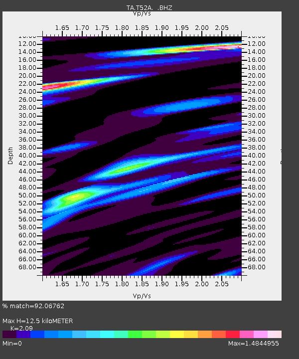
| Estimated Moho Depth: |
12.5 km |
| Estimated Crust Vp/Vs: |
2.09 |
| Assumed Crust Vp: |
6.476 km/s |
| Estimated Crust Vs: |
3.099 km/s |
| Estimated Crust Poisson's Ratio: |
0.35 |
|
| Radial Match: |
92.06762 % |
| Radial Bump: |
400 |
| Transverse Match: |
68.45967 % |
| Transverse Bump: |
400 |
| SOD ConfigId: |
469095 |
| Insert Time: |
2013-02-22 03:45:45.222 +0000 |
| GWidth: |
2.5 |
| Max Bumps: |
400 |
| Tol: |
0.001 |
|

Signal To Noise
| Channel | StoN | STA | LTA |
| TA:T52A: :BHZ:20120802T09:46:09.274988Z | 15.258448 | 1.1595598E-6 | 7.599461E-8 |
| TA:T52A: :BHN:20120802T09:46:09.274988Z | 8.871219 | 5.9780245E-7 | 6.738673E-8 |
| TA:T52A: :BHE:20120802T09:46:09.274988Z | 2.907681 | 1.841356E-7 | 6.3327306E-8 |
| Arrivals |
| Ps | 2.2 SECOND |
| PpPs | 5.7 SECOND |
| PsPs/PpSs | 7.9 SECOND |


