You are here: Home > Network List > TA - USArray Transportable Network (new EarthScope stations) Stations List
> Station T49A Edmonton, KY, USA > Earthquake Result Viewer
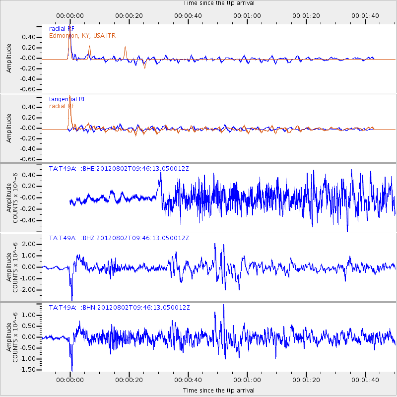
T49A Edmonton, KY, USA - Earthquake Result Viewer

| Earthquake location: |
Peru-Brazil Border Region |
| Earthquake latitude/longitude: |
-8.4/-74.3 |
| Earthquake time(UTC): |
2012/08/02 (215) 09:38:30 GMT |
| Earthquake Depth: |
145 km |
| Earthquake Magnitude: |
5.9 MB, 6.1 MW, 6.1 MW |
| Earthquake Catalog/Contributor: |
WHDF/NEIC |
|
| Network: |
TA USArray Transportable Network (new EarthScope stations) |
| Station: |
T49A Edmonton, KY, USA |
| Lat/Lon: |
37.10 N/85.53 W |
| Elevation: |
313 m |
|
| Distance: |
46.5 deg |
| Az: |
347.556 deg |
| Baz: |
164.533 deg |
| Ray Param: |
0.070078604 |
| Estimated Moho Depth: |
62.25 km |
| Estimated Crust Vp/Vs: |
1.61 |
| Assumed Crust Vp: |
6.476 km/s |
| Estimated Crust Vs: |
4.029 km/s |
| Estimated Crust Poisson's Ratio: |
0.18 |
|
| Radial Match: |
88.90519 % |
| Radial Bump: |
400 |
| Transverse Match: |
75.56991 % |
| Transverse Bump: |
400 |
| SOD ConfigId: |
469095 |
| Insert Time: |
2013-02-22 03:46:17.739 +0000 |
| GWidth: |
2.5 |
| Max Bumps: |
400 |
| Tol: |
0.001 |
|
Signal To Noise
| Channel | StoN | STA | LTA |
| TA:T49A: :BHZ:20120802T09:46:13.050012Z | 10.696116 | 9.436831E-7 | 8.8226706E-8 |
| TA:T49A: :BHN:20120802T09:46:13.050012Z | 7.712055 | 4.7308433E-7 | 6.1343485E-8 |
| TA:T49A: :BHE:20120802T09:46:13.050012Z | 3.6218948 | 1.8700261E-7 | 5.1631154E-8 |
| Arrivals |
| Ps | 6.3 SECOND |
| PpPs | 23 SECOND |
| PsPs/PpSs | 30 SECOND |


