You are here: Home > Network List > TA - USArray Transportable Network (new EarthScope stations) Stations List
> Station U51A La Follette, TN, USA > Earthquake Result Viewer
U51A La Follette, TN, USA - Earthquake Result Viewer
| Earthquake location: |
Peru-Brazil Border Region |
| Earthquake latitude/longitude: |
-8.4/-74.3 |
| Earthquake time(UTC): |
2012/08/02 (215) 09:38:30 GMT |
| Earthquake Depth: |
145 km |
| Earthquake Magnitude: |
5.9 MB, 6.1 MW, 6.1 MW |
| Earthquake Catalog/Contributor: |
WHDF/NEIC |
|
| Network: |
TA USArray Transportable Network (new EarthScope stations) |
| Station: |
U51A La Follette, TN, USA |
| Lat/Lon: |
36.38 N/84.02 W |
| Elevation: |
472 m |
|
| Distance: |
45.5 deg |
| Az: |
348.943 deg |
| Baz: |
166.4 deg |
| Ray Param: |
0.07072477 |
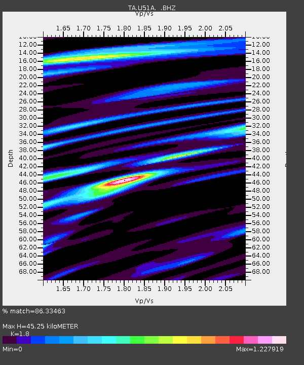
| Estimated Moho Depth: |
45.25 km |
| Estimated Crust Vp/Vs: |
1.80 |
| Assumed Crust Vp: |
6.476 km/s |
| Estimated Crust Vs: |
3.598 km/s |
| Estimated Crust Poisson's Ratio: |
0.28 |
|
| Radial Match: |
86.33463 % |
| Radial Bump: |
400 |
| Transverse Match: |
64.430534 % |
| Transverse Bump: |
400 |
| SOD ConfigId: |
469095 |
| Insert Time: |
2013-02-22 03:46:42.595 +0000 |
| GWidth: |
2.5 |
| Max Bumps: |
400 |
| Tol: |
0.001 |
|
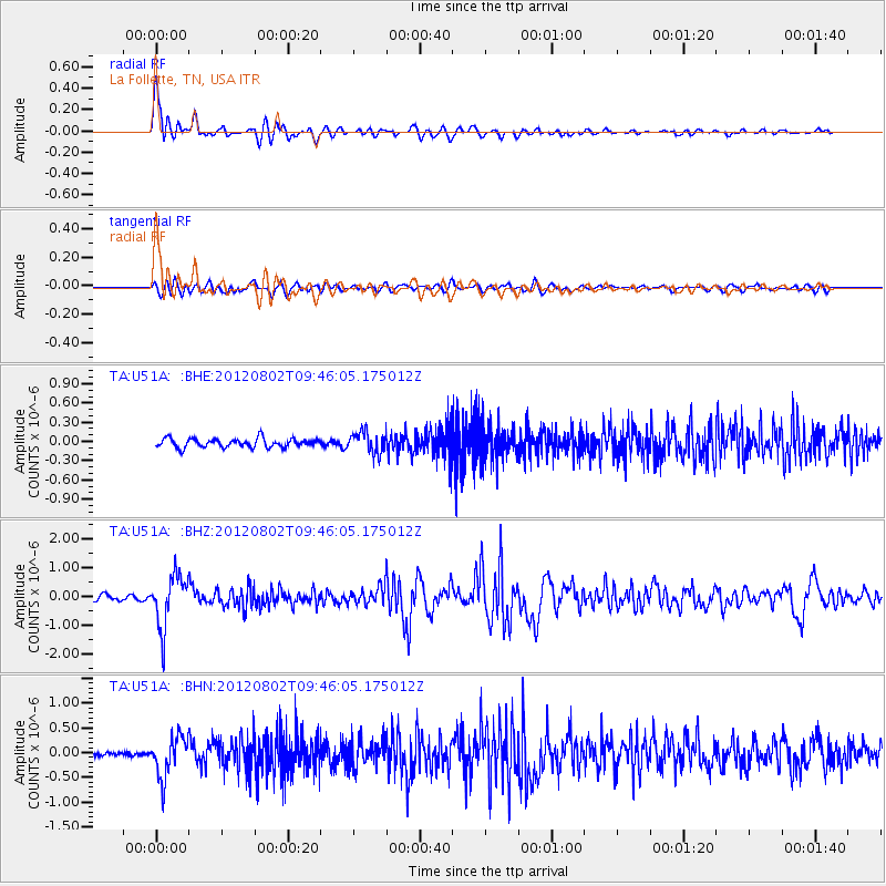
Signal To Noise
| Channel | StoN | STA | LTA |
| TA:U51A: :BHZ:20120802T09:46:05.175012Z | 11.154948 | 9.186092E-7 | 8.2349935E-8 |
| TA:U51A: :BHN:20120802T09:46:05.175012Z | 7.782598 | 4.080859E-7 | 5.2435688E-8 |
| TA:U51A: :BHE:20120802T09:46:05.175012Z | 2.4139218 | 1.6412108E-7 | 6.798939E-8 |
| Arrivals |
| Ps | 6.0 SECOND |
| PpPs | 18 SECOND |
| PsPs/PpSs | 24 SECOND |


