You are here: Home > Network List > TA - USArray Transportable Network (new EarthScope stations) Stations List
> Station R49A Shelbyville, KY, USA > Earthquake Result Viewer
R49A Shelbyville, KY, USA - Earthquake Result Viewer
| Earthquake location: |
Peru-Brazil Border Region |
| Earthquake latitude/longitude: |
-8.4/-74.3 |
| Earthquake time(UTC): |
2012/08/02 (215) 09:38:30 GMT |
| Earthquake Depth: |
145 km |
| Earthquake Magnitude: |
5.9 MB, 6.1 MW, 6.1 MW |
| Earthquake Catalog/Contributor: |
WHDF/NEIC |
|
| Network: |
TA USArray Transportable Network (new EarthScope stations) |
| Station: |
R49A Shelbyville, KY, USA |
| Lat/Lon: |
38.29 N/85.17 W |
| Elevation: |
251 m |
|
| Distance: |
47.6 deg |
| Az: |
348.356 deg |
| Baz: |
165.299 deg |
| Ray Param: |
0.06941056 |
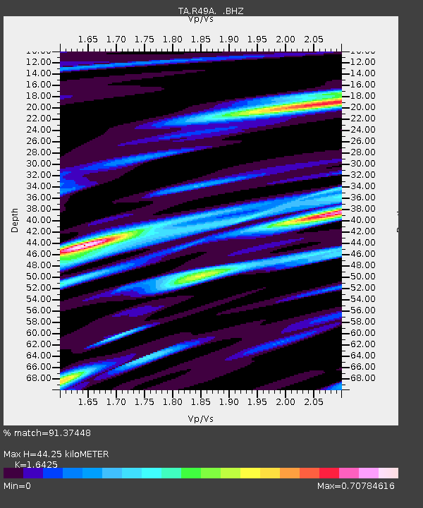
| Estimated Moho Depth: |
44.25 km |
| Estimated Crust Vp/Vs: |
1.64 |
| Assumed Crust Vp: |
6.498 km/s |
| Estimated Crust Vs: |
3.956 km/s |
| Estimated Crust Poisson's Ratio: |
0.21 |
|
| Radial Match: |
91.37448 % |
| Radial Bump: |
400 |
| Transverse Match: |
79.90667 % |
| Transverse Bump: |
400 |
| SOD ConfigId: |
469095 |
| Insert Time: |
2013-02-22 03:46:56.174 +0000 |
| GWidth: |
2.5 |
| Max Bumps: |
400 |
| Tol: |
0.001 |
|

Signal To Noise
| Channel | StoN | STA | LTA |
| TA:R49A: :BHZ:20120802T09:46:21.300012Z | 14.033231 | 9.3050545E-7 | 6.630729E-8 |
| TA:R49A: :BHN:20120802T09:46:21.300012Z | 9.607617 | 4.6337823E-7 | 4.8230294E-8 |
| TA:R49A: :BHE:20120802T09:46:21.300012Z | 3.5973327 | 1.3357237E-7 | 3.7130945E-8 |
| Arrivals |
| Ps | 4.7 SECOND |
| PpPs | 17 SECOND |
| PsPs/PpSs | 22 SECOND |


