You are here: Home > Network List > TA - USArray Transportable Network (new EarthScope stations) Stations List
> Station TFRD Ford Ranch, Anza, CA, USA > Earthquake Result Viewer
TFRD Ford Ranch, Anza, CA, USA - Earthquake Result Viewer

| Earthquake location: |
Peru-Brazil Border Region |
| Earthquake latitude/longitude: |
-8.4/-74.3 |
| Earthquake time(UTC): |
2012/08/02 (215) 09:38:30 GMT |
| Earthquake Depth: |
145 km |
| Earthquake Magnitude: |
5.9 MB, 6.1 MW, 6.1 MW |
| Earthquake Catalog/Contributor: |
WHDF/NEIC |
|
| Network: |
TA USArray Transportable Network (new EarthScope stations) |
| Station: |
TFRD Ford Ranch, Anza, CA, USA |
| Lat/Lon: |
33.49 N/116.60 W |
| Elevation: |
1000 m |
|
| Distance: |
57.9 deg |
| Az: |
318.367 deg |
| Baz: |
128.133 deg |
| Ray Param: |
0.06273603 |
| Estimated Moho Depth: |
28.0 km |
| Estimated Crust Vp/Vs: |
1.63 |
| Assumed Crust Vp: |
6.264 km/s |
| Estimated Crust Vs: |
3.831 km/s |
| Estimated Crust Poisson's Ratio: |
0.20 |
|
| Radial Match: |
94.46877 % |
| Radial Bump: |
400 |
| Transverse Match: |
78.95865 % |
| Transverse Bump: |
400 |
| SOD ConfigId: |
469095 |
| Insert Time: |
2013-02-22 03:47:39.411 +0000 |
| GWidth: |
2.5 |
| Max Bumps: |
400 |
| Tol: |
0.001 |
|
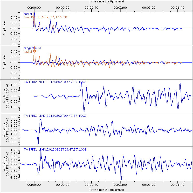
Signal To Noise
| Channel | StoN | STA | LTA |
| TA:TFRD: :BHZ:20120802T09:47:37.100Z | 17.934565 | 1.5150039E-6 | 8.4473974E-8 |
| TA:TFRD: :BHN:20120802T09:47:37.100Z | 10.085135 | 4.583096E-7 | 4.5444068E-8 |
| TA:TFRD: :BHE:20120802T09:47:37.100Z | 6.508422 | 5.806223E-7 | 8.921092E-8 |
| Arrivals |
| Ps | 3.0 SECOND |
| PpPs | 11 SECOND |
| PsPs/PpSs | 14 SECOND |


