You are here: Home > Network List > G - GEOSCOPE Stations List
> Station TAM Tamanrasset, Algeria > Earthquake Result Viewer
TAM Tamanrasset, Algeria - Earthquake Result Viewer
| Earthquake location: |
Near Coast Of Peru |
| Earthquake latitude/longitude: |
-13.4/-76.6 |
| Earthquake time(UTC): |
2007/08/15 (227) 23:40:57 GMT |
| Earthquake Depth: |
39 km |
| Earthquake Magnitude: |
6.7 MB, 7.9 MS, 8.0 MW, 7.5 ME |
| Earthquake Catalog/Contributor: |
WHDF/NEIC |
|
| Network: |
G GEOSCOPE |
| Station: |
TAM Tamanrasset, Algeria |
| Lat/Lon: |
22.79 N/5.53 E |
| Elevation: |
1377 m |
|
| Distance: |
88.0 deg |
| Az: |
66.163 deg |
| Baz: |
254.706 deg |
| Ray Param: |
0.042833094 |
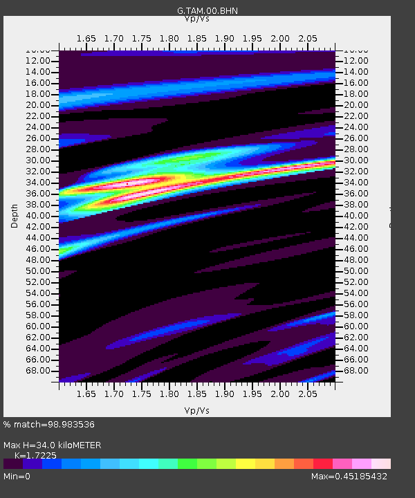
| Estimated Moho Depth: |
34.0 km |
| Estimated Crust Vp/Vs: |
1.72 |
| Assumed Crust Vp: |
6.61 km/s |
| Estimated Crust Vs: |
3.837 km/s |
| Estimated Crust Poisson's Ratio: |
0.25 |
|
| Radial Match: |
98.983536 % |
| Radial Bump: |
172 |
| Transverse Match: |
91.78531 % |
| Transverse Bump: |
400 |
| SOD ConfigId: |
2564 |
| Insert Time: |
2010-02-27 00:30:52.312 +0000 |
| GWidth: |
2.5 |
| Max Bumps: |
400 |
| Tol: |
0.001 |
|
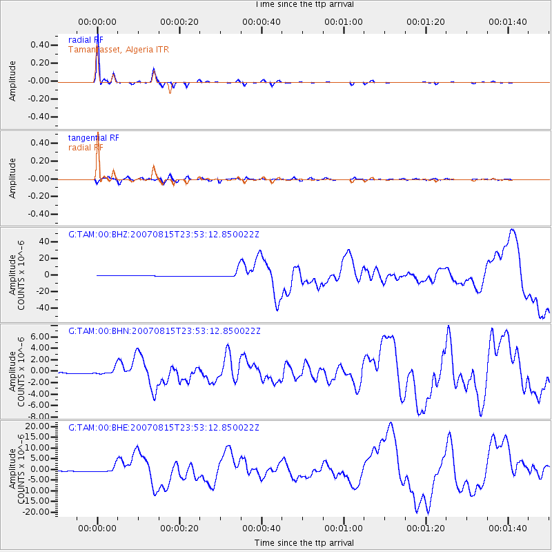
Signal To Noise
| Channel | StoN | STA | LTA |
| G:TAM:00:BHN:20070815T23:53:12.850022Z | 6.4868884 | 6.0533597E-7 | 9.331685E-8 |
| G:TAM:00:BHE:20070815T23:53:12.850022Z | 10.075029 | 1.5872099E-6 | 1.5753898E-7 |
| G:TAM:00:BHZ:20070815T23:53:12.850022Z | 12.783018 | 5.6787617E-6 | 4.4424266E-7 |
| Arrivals |
| Ps | 3.8 SECOND |
| PpPs | 14 SECOND |
| PsPs/PpSs | 17 SECOND |


