You are here: Home > Network List > TA - USArray Transportable Network (new EarthScope stations) Stations List
> Station O03D Paynes Creek, CA, USA > Earthquake Result Viewer
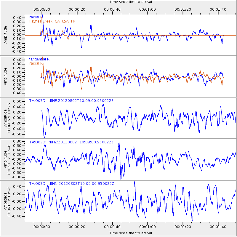
O03D Paynes Creek, CA, USA - Earthquake Result Viewer
*The percent match for this event was below the threshold and hence no stack was calculated.
| Earthquake location: |
New Ireland Region, P.N.G. |
| Earthquake latitude/longitude: |
-4.7/153.3 |
| Earthquake time(UTC): |
2012/08/02 (215) 09:56:41 GMT |
| Earthquake Depth: |
46 km |
| Earthquake Magnitude: |
5.8 MB, 5.7 MS, 6.1 MW, 6.1 MW |
| Earthquake Catalog/Contributor: |
WHDF/NEIC |
|
| Network: |
TA USArray Transportable Network (new EarthScope stations) |
| Station: |
O03D Paynes Creek, CA, USA |
| Lat/Lon: |
40.29 N/121.80 W |
| Elevation: |
968 m |
|
| Distance: |
89.1 deg |
| Az: |
49.637 deg |
| Baz: |
263.196 deg |
| Ray Param: |
$rayparam |
*The percent match for this event was below the threshold and hence was not used in the summary stack. |
|
| Radial Match: |
51.30787 % |
| Radial Bump: |
400 |
| Transverse Match: |
64.116554 % |
| Transverse Bump: |
395 |
| SOD ConfigId: |
469095 |
| Insert Time: |
2013-02-22 04:00:45.556 +0000 |
| GWidth: |
2.5 |
| Max Bumps: |
400 |
| Tol: |
0.001 |
|
Signal To Noise
| Channel | StoN | STA | LTA |
| TA:O03D: :BHZ:20120802T10:09:00.950022Z | 4.065581 | 3.2747525E-7 | 8.0548205E-8 |
| TA:O03D: :BHN:20120802T10:09:00.950022Z | 1.6975406 | 2.5759135E-7 | 1.5174385E-7 |
| TA:O03D: :BHE:20120802T10:09:00.950022Z | 1.2576663 | 2.899259E-7 | 2.305269E-7 |
| Arrivals |
| Ps | |
| PpPs | |
| PsPs/PpSs | |


