You are here: Home > Network List > TA - USArray Transportable Network (new EarthScope stations) Stations List
> Station Z40A Long Farm, Magnolia, AR, USA > Earthquake Result Viewer
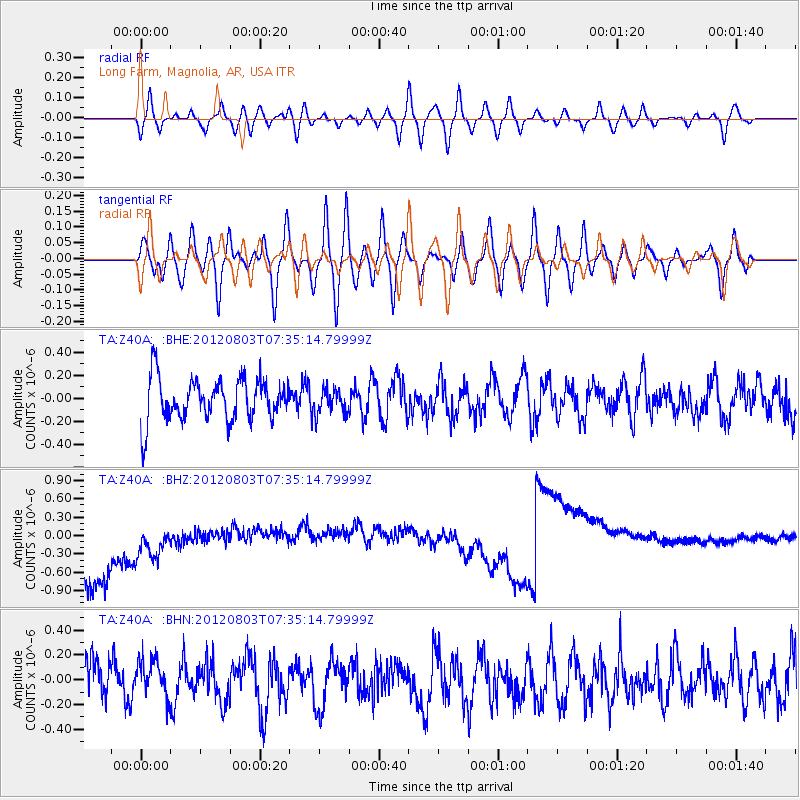
Z40A Long Farm, Magnolia, AR, USA - Earthquake Result Viewer
*The percent match for this event was below the threshold and hence no stack was calculated.
| Earthquake location: |
Fiji Islands Region |
| Earthquake latitude/longitude: |
-16.9/-176.9 |
| Earthquake time(UTC): |
2012/08/03 (216) 07:22:30 GMT |
| Earthquake Depth: |
20 km |
| Earthquake Magnitude: |
5.5 MW, 5.1 MS, 5.0 MB, 5.5 MW |
| Earthquake Catalog/Contributor: |
WHDF/NEIC |
|
| Network: |
TA USArray Transportable Network (new EarthScope stations) |
| Station: |
Z40A Long Farm, Magnolia, AR, USA |
| Lat/Lon: |
33.26 N/93.40 W |
| Elevation: |
78 m |
|
| Distance: |
93.9 deg |
| Az: |
56.556 deg |
| Baz: |
252.42 deg |
| Ray Param: |
$rayparam |
*The percent match for this event was below the threshold and hence was not used in the summary stack. |
|
| Radial Match: |
46.833466 % |
| Radial Bump: |
400 |
| Transverse Match: |
51.135456 % |
| Transverse Bump: |
400 |
| SOD ConfigId: |
469095 |
| Insert Time: |
2013-02-22 04:07:47.007 +0000 |
| GWidth: |
2.5 |
| Max Bumps: |
400 |
| Tol: |
0.001 |
|
Signal To Noise
| Channel | StoN | STA | LTA |
| TA:Z40A: :BHZ:20120803T07:35:14.79999Z | 0.93674165 | 5.192796E-7 | 5.543466E-7 |
| TA:Z40A: :BHN:20120803T07:35:14.79999Z | 0.9356677 | 1.5339431E-7 | 1.6394102E-7 |
| TA:Z40A: :BHE:20120803T07:35:14.79999Z | 0.554708 | 1.0294449E-7 | 1.8558322E-7 |
| Arrivals |
| Ps | |
| PpPs | |
| PsPs/PpSs | |


