You are here: Home > Network List > YT07 - POLENET Stations List
> Station WAWA WAWA > Earthquake Result Viewer
WAWA WAWA - Earthquake Result Viewer
| Earthquake location: |
Pacific-Antarctic Ridge |
| Earthquake latitude/longitude: |
-55.0/-129.6 |
| Earthquake time(UTC): |
2014/06/03 (154) 04:39:57 GMT |
| Earthquake Depth: |
13 km |
| Earthquake Magnitude: |
5.6 MWC, 5.6 MWC |
| Earthquake Catalog/Contributor: |
NEIC PDE/NEIC COMCAT |
|
| Network: |
YT POLENET |
| Station: |
WAWA WAWA |
| Lat/Lon: |
81.58 S/28.42 W |
| Elevation: |
1202 m |
|
| Distance: |
37.7 deg |
| Az: |
166.312 deg |
| Baz: |
247.765 deg |
| Ray Param: |
0.075999305 |
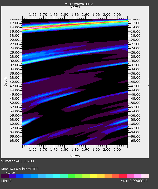
| Estimated Moho Depth: |
14.5 km |
| Estimated Crust Vp/Vs: |
1.60 |
| Assumed Crust Vp: |
6.424 km/s |
| Estimated Crust Vs: |
4.015 km/s |
| Estimated Crust Poisson's Ratio: |
0.18 |
|
| Radial Match: |
81.33783 % |
| Radial Bump: |
400 |
| Transverse Match: |
68.58823 % |
| Transverse Bump: |
400 |
| SOD ConfigId: |
3390531 |
| Insert Time: |
2019-04-12 04:00:49.086 +0000 |
| GWidth: |
2.5 |
| Max Bumps: |
400 |
| Tol: |
0.001 |
|

Signal To Noise
| Channel | StoN | STA | LTA |
| YT:WAWA: :BHZ:20140603T04:46:41.624011Z | 4.640602 | 3.0692604E-7 | 6.613928E-8 |
| YT:WAWA: :BHN:20140603T04:46:41.624011Z | 1.4666169 | 7.82645E-8 | 5.336397E-8 |
| YT:WAWA: :BHE:20140603T04:46:41.624011Z | 2.3086379 | 1.682327E-7 | 7.2870975E-8 |
| Arrivals |
| Ps | 1.5 SECOND |
| PpPs | 5.4 SECOND |
| PsPs/PpSs | 6.9 SECOND |


