You are here: Home > Network List > G - GEOSCOPE Stations List
> Station TAM Tamanrasset, Algeria > Earthquake Result Viewer
TAM Tamanrasset, Algeria - Earthquake Result Viewer
| Earthquake location: |
Qinghai, China |
| Earthquake latitude/longitude: |
37.6/95.8 |
| Earthquake time(UTC): |
2008/11/10 (315) 01:22:02 GMT |
| Earthquake Depth: |
19 km |
| Earthquake Magnitude: |
6.4 MB, 6.4 MS, 6.3 MW, 6.3 MW |
| Earthquake Catalog/Contributor: |
WHDF/NEIC |
|
| Network: |
G GEOSCOPE |
| Station: |
TAM Tamanrasset, Algeria |
| Lat/Lon: |
22.79 N/5.53 E |
| Elevation: |
1377 m |
|
| Distance: |
76.7 deg |
| Az: |
288.516 deg |
| Baz: |
54.736 deg |
| Ray Param: |
0.05079593 |
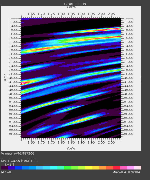
| Estimated Moho Depth: |
42.5 km |
| Estimated Crust Vp/Vs: |
1.60 |
| Assumed Crust Vp: |
6.61 km/s |
| Estimated Crust Vs: |
4.131 km/s |
| Estimated Crust Poisson's Ratio: |
0.18 |
|
| Radial Match: |
96.987206 % |
| Radial Bump: |
330 |
| Transverse Match: |
86.07925 % |
| Transverse Bump: |
400 |
| SOD ConfigId: |
2658 |
| Insert Time: |
2010-02-27 00:31:21.810 +0000 |
| GWidth: |
2.5 |
| Max Bumps: |
400 |
| Tol: |
0.001 |
|
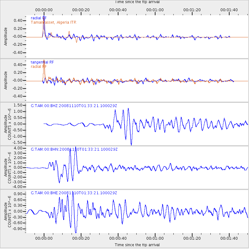
Signal To Noise
| Channel | StoN | STA | LTA |
| G:TAM:00:BHN:20081110T01:33:21.100029Z | 8.845204 | 5.8197566E-7 | 6.579561E-8 |
| G:TAM:00:BHE:20081110T01:33:21.100029Z | 3.1463547 | 1.3975557E-7 | 4.4418254E-8 |
| G:TAM:00:BHZ:20081110T01:33:21.100029Z | 1.7389735 | 1.2230603E-7 | 7.033231E-8 |
| Arrivals |
| Ps | 4.0 SECOND |
| PpPs | 16 SECOND |
| PsPs/PpSs | 20 SECOND |


