You are here: Home > Network List > AZ - ANZA Regional Network Stations List
> Station SMER AZ.SMER > Earthquake Result Viewer
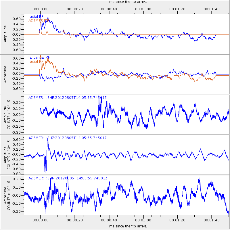
SMER AZ.SMER - Earthquake Result Viewer
*The percent match for this event was below the threshold and hence no stack was calculated.
| Earthquake location: |
Fiji Islands Region |
| Earthquake latitude/longitude: |
-21.1/-178.4 |
| Earthquake time(UTC): |
2012/08/05 (218) 13:55:10 GMT |
| Earthquake Depth: |
484 km |
| Earthquake Magnitude: |
5.5 MB, 5.8 MW, 5.9 MW |
| Earthquake Catalog/Contributor: |
WHDF/NEIC |
|
| Network: |
AZ ANZA Regional Network |
| Station: |
SMER AZ.SMER |
| Lat/Lon: |
33.46 N/117.17 W |
| Elevation: |
355 m |
|
| Distance: |
79.7 deg |
| Az: |
48.121 deg |
| Baz: |
236.238 deg |
| Ray Param: |
$rayparam |
*The percent match for this event was below the threshold and hence was not used in the summary stack. |
|
| Radial Match: |
46.493443 % |
| Radial Bump: |
400 |
| Transverse Match: |
50.571625 % |
| Transverse Bump: |
400 |
| SOD ConfigId: |
469095 |
| Insert Time: |
2013-02-22 04:14:11.548 +0000 |
| GWidth: |
2.5 |
| Max Bumps: |
400 |
| Tol: |
0.001 |
|
Signal To Noise
| Channel | StoN | STA | LTA |
| AZ:SMER: :BHZ:20120805T14:05:55.74501Z | 6.095899 | 3.2345935E-7 | 5.3061797E-8 |
| AZ:SMER: :BHN:20120805T14:05:55.74501Z | 1.0010267 | 6.427584E-8 | 6.4209914E-8 |
| AZ:SMER: :BHE:20120805T14:05:55.74501Z | 1.7011575 | 1.14171264E-7 | 6.7113874E-8 |
| Arrivals |
| Ps | |
| PpPs | |
| PsPs/PpSs | |


