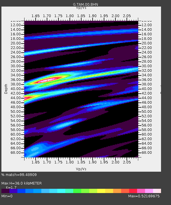
TAM Tamanrasset, Algeria - Earthquake Result Viewer
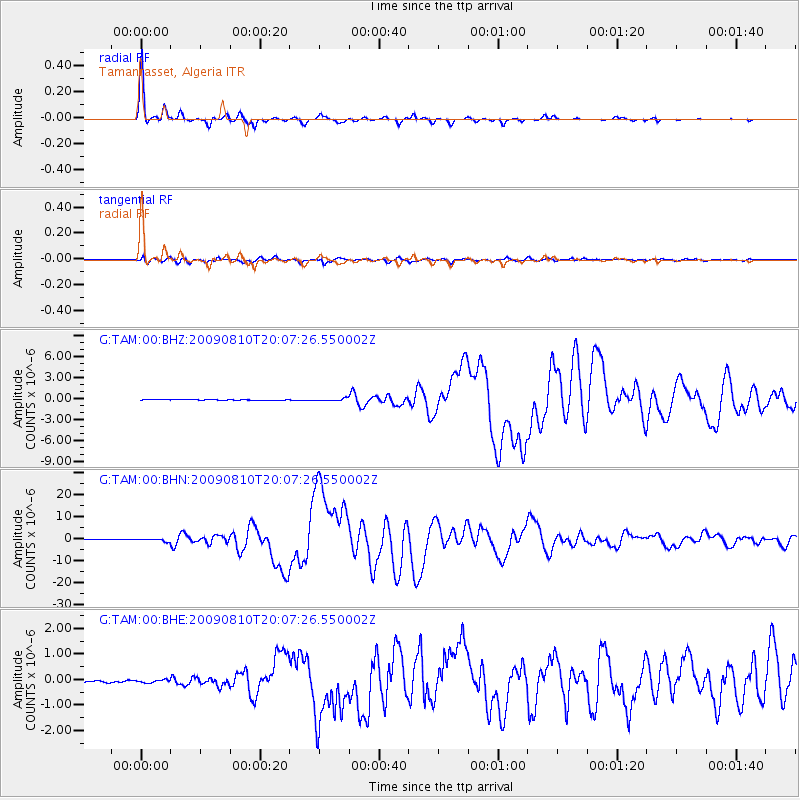
Earthquake location: Andaman Islands, India Region
Earthquake latitude/longitude: 14.1/92.9
Earthquake time(UTC): 2009/08/10 (222) 19:55:35 GMT
Earthquake Depth: 4.7 km
Earthquake Magnitude: 6.9 MB, 7.6 MS, 7.5 MW, 7.5 MW
Earthquake Catalog/Contributor: WHDF/NEIC
Network: G GEOSCOPE
Station: TAM Tamanrasset, Algeria
Lat/Lon: 22.79 N/5.53 E
Elevation: 1377 m
Distance: 82.3 deg
Az: 291.516 deg
Baz: 77.991 deg
Ray Param: 0.047011327
Estimated Moho Depth: 36.0 km
Estimated Crust Vp/Vs: 1.70
Assumed Crust Vp: 6.61 km/s
Estimated Crust Vs: 3.888 km/s
Estimated Crust Poisson's Ratio: 0.24
Radial Match: 99.48909 %
Radial Bump: 228
Transverse Match: 96.158966 %
Transverse Bump: 400
SOD ConfigId: 2622
Insert Time: 2010-02-27 00:31:32.920 +0000
GWidth: 2.5
Max Bumps: 400
Tol: 0.001

Signal To Noise

ChannelStoNSTALTA
G:TAM:00:BHN:20090810T20:07:26.550002Z6.525085.254651E-78.0530064E-8
G:TAM:00:BHE:20090810T20:07:26.550002Z1.1848415.6635713E-84.7800263E-8
G:TAM:00:BHZ:20090810T20:07:26.550002Z4.75358061.6892744E-73.5536885E-8
Arrivals
Ps3.9 SECOND
PpPs14 SECOND
PsPs/PpSs18 SECOND