You are here: Home > Network List > 7A - Mid-Atlantic Geophysical Integrative Collaboration Stations List
> Station WINE Liberty, Virginia USA > Earthquake Result Viewer
WINE Liberty, Virginia USA - Earthquake Result Viewer
| Earthquake location: |
Southeastern Alaska |
| Earthquake latitude/longitude: |
59.0/-136.7 |
| Earthquake time(UTC): |
2014/06/04 (155) 11:58:58 GMT |
| Earthquake Depth: |
10 km |
| Earthquake Magnitude: |
5.7 MWP, 5.8 ML, 5.8 MI |
| Earthquake Catalog/Contributor: |
NEIC PDE/NEIC COMCAT |
|
| Network: |
7A Mid-Atlantic Geophysical Integrative Collaboration |
| Station: |
WINE Liberty, Virginia USA |
| Lat/Lon: |
38.16 N/78.32 W |
| Elevation: |
119 m |
|
| Distance: |
42.2 deg |
| Az: |
93.038 deg |
| Baz: |
319.031 deg |
| Ray Param: |
0.07330316 |
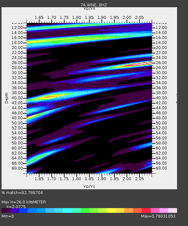
| Estimated Moho Depth: |
26.0 km |
| Estimated Crust Vp/Vs: |
2.08 |
| Assumed Crust Vp: |
6.159 km/s |
| Estimated Crust Vs: |
2.964 km/s |
| Estimated Crust Poisson's Ratio: |
0.35 |
|
| Radial Match: |
82.788704 % |
| Radial Bump: |
355 |
| Transverse Match: |
62.818726 % |
| Transverse Bump: |
400 |
| SOD ConfigId: |
3390531 |
| Insert Time: |
2019-04-12 04:05:23.741 +0000 |
| GWidth: |
2.5 |
| Max Bumps: |
400 |
| Tol: |
0.001 |
|

Signal To Noise
| Channel | StoN | STA | LTA |
| 7A:WINE: :BHZ:20140604T12:06:20.849994Z | 2.881816 | 3.6766065E-7 | 1.275795E-7 |
| 7A:WINE: :BHN:20140604T12:06:20.849994Z | 2.2206528 | 1.8058785E-7 | 8.132196E-8 |
| 7A:WINE: :BHE:20140604T12:06:20.849994Z | 1.1511455 | 1.0276014E-7 | 8.926772E-8 |
| Arrivals |
| Ps | 4.8 SECOND |
| PpPs | 12 SECOND |
| PsPs/PpSs | 17 SECOND |


