You are here: Home > Network List > TA - USArray Transportable Network (new EarthScope stations) Stations List
> Station T25A Trinidad, CO, USA > Earthquake Result Viewer
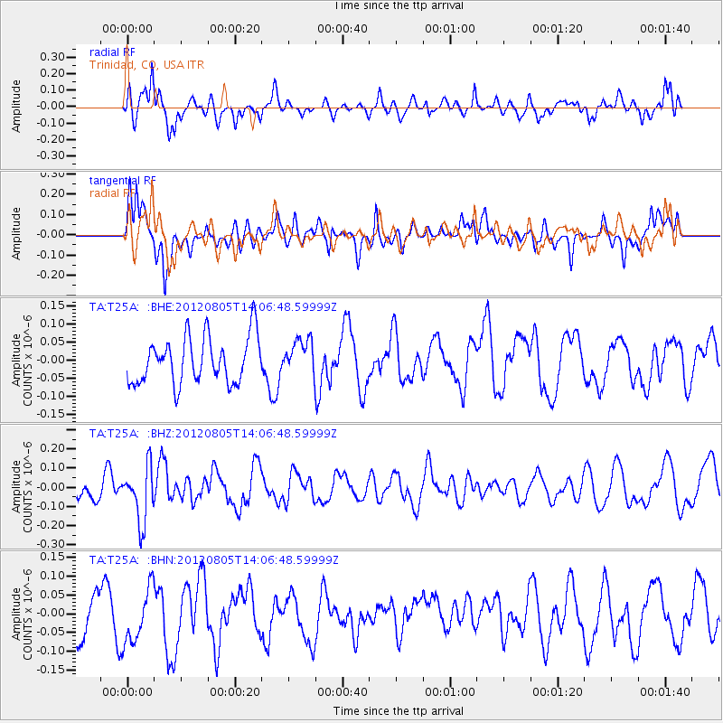
T25A Trinidad, CO, USA - Earthquake Result Viewer
*The percent match for this event was below the threshold and hence no stack was calculated.
| Earthquake location: |
Fiji Islands Region |
| Earthquake latitude/longitude: |
-21.1/-178.4 |
| Earthquake time(UTC): |
2012/08/05 (218) 13:55:10 GMT |
| Earthquake Depth: |
484 km |
| Earthquake Magnitude: |
5.5 MB, 5.8 MW, 5.9 MW |
| Earthquake Catalog/Contributor: |
WHDF/NEIC |
|
| Network: |
TA USArray Transportable Network (new EarthScope stations) |
| Station: |
T25A Trinidad, CO, USA |
| Lat/Lon: |
37.14 N/104.41 W |
| Elevation: |
2017 m |
|
| Distance: |
90.5 deg |
| Az: |
50.174 deg |
| Baz: |
243.778 deg |
| Ray Param: |
$rayparam |
*The percent match for this event was below the threshold and hence was not used in the summary stack. |
|
| Radial Match: |
71.920906 % |
| Radial Bump: |
400 |
| Transverse Match: |
63.02502 % |
| Transverse Bump: |
400 |
| SOD ConfigId: |
469095 |
| Insert Time: |
2013-02-22 04:23:20.418 +0000 |
| GWidth: |
2.5 |
| Max Bumps: |
400 |
| Tol: |
0.001 |
|
Signal To Noise
| Channel | StoN | STA | LTA |
| TA:T25A: :BHZ:20120805T14:06:48.59999Z | 2.3027053 | 1.4524313E-7 | 6.3075E-8 |
| TA:T25A: :BHN:20120805T14:06:48.59999Z | 1.2545513 | 7.495125E-8 | 5.974348E-8 |
| TA:T25A: :BHE:20120805T14:06:48.59999Z | 0.75900316 | 4.9157435E-8 | 6.476578E-8 |
| Arrivals |
| Ps | |
| PpPs | |
| PsPs/PpSs | |


