You are here: Home > Network List > TA - USArray Transportable Network (new EarthScope stations) Stations List
> Station L04D Klamath Falls, OR, USA > Earthquake Result Viewer
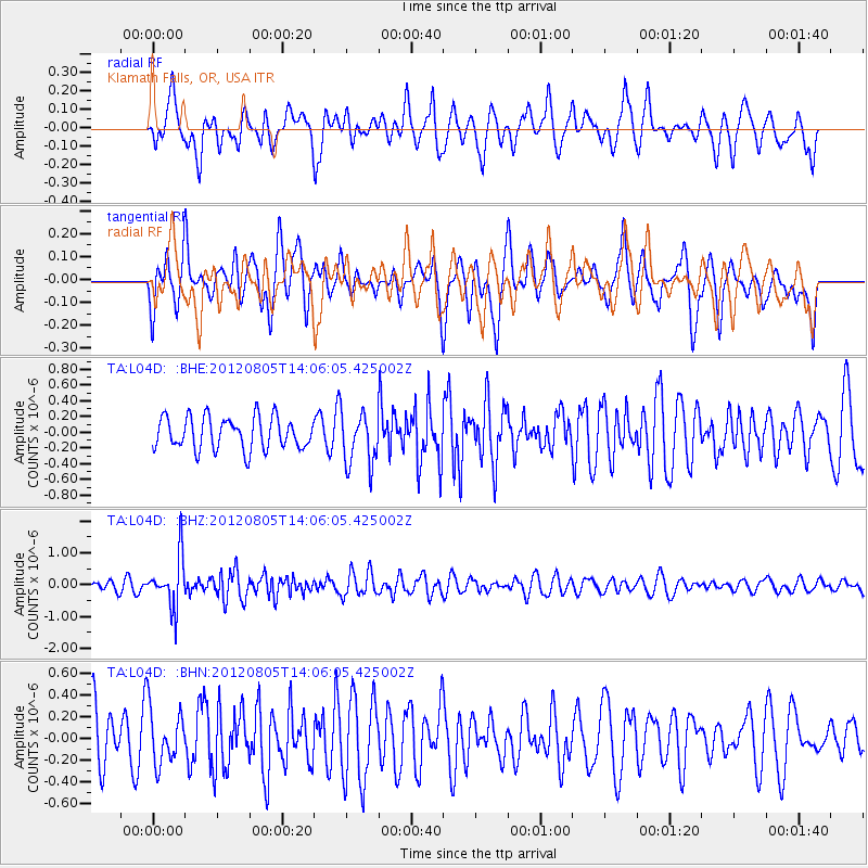
L04D Klamath Falls, OR, USA - Earthquake Result Viewer
*The percent match for this event was below the threshold and hence no stack was calculated.
| Earthquake location: |
Fiji Islands Region |
| Earthquake latitude/longitude: |
-21.1/-178.4 |
| Earthquake time(UTC): |
2012/08/05 (218) 13:55:10 GMT |
| Earthquake Depth: |
484 km |
| Earthquake Magnitude: |
5.5 MB, 5.8 MW, 5.9 MW |
| Earthquake Catalog/Contributor: |
WHDF/NEIC |
|
| Network: |
TA USArray Transportable Network (new EarthScope stations) |
| Station: |
L04D Klamath Falls, OR, USA |
| Lat/Lon: |
42.22 N/122.30 W |
| Elevation: |
1437 m |
|
| Distance: |
81.5 deg |
| Az: |
38.535 deg |
| Baz: |
231.523 deg |
| Ray Param: |
$rayparam |
*The percent match for this event was below the threshold and hence was not used in the summary stack. |
|
| Radial Match: |
61.164658 % |
| Radial Bump: |
400 |
| Transverse Match: |
53.59216 % |
| Transverse Bump: |
400 |
| SOD ConfigId: |
469095 |
| Insert Time: |
2013-02-22 04:24:37.839 +0000 |
| GWidth: |
2.5 |
| Max Bumps: |
400 |
| Tol: |
0.001 |
|
Signal To Noise
| Channel | StoN | STA | LTA |
| TA:L04D: :BHZ:20120805T14:06:05.425002Z | 5.4400187 | 7.887464E-7 | 1.4498964E-7 |
| TA:L04D: :BHN:20120805T14:06:05.425002Z | 0.9589272 | 2.553209E-7 | 2.6625682E-7 |
| TA:L04D: :BHE:20120805T14:06:05.425002Z | 1.6655233 | 3.3843796E-7 | 2.0320218E-7 |
| Arrivals |
| Ps | |
| PpPs | |
| PsPs/PpSs | |


