You are here: Home > Network List > TA - USArray Transportable Network (new EarthScope stations) Stations List
> Station A04D Lummi Island, WA, USA > Earthquake Result Viewer
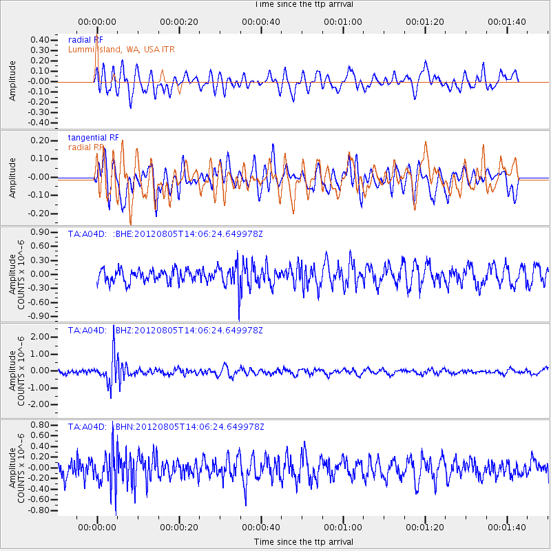
A04D Lummi Island, WA, USA - Earthquake Result Viewer
*The percent match for this event was below the threshold and hence no stack was calculated.
| Earthquake location: |
Fiji Islands Region |
| Earthquake latitude/longitude: |
-21.1/-178.4 |
| Earthquake time(UTC): |
2012/08/05 (218) 13:55:10 GMT |
| Earthquake Depth: |
484 km |
| Earthquake Magnitude: |
5.5 MB, 5.8 MW, 5.9 MW |
| Earthquake Catalog/Contributor: |
WHDF/NEIC |
|
| Network: |
TA USArray Transportable Network (new EarthScope stations) |
| Station: |
A04D Lummi Island, WA, USA |
| Lat/Lon: |
48.72 N/122.71 W |
| Elevation: |
13 m |
|
| Distance: |
85.4 deg |
| Az: |
33.265 deg |
| Baz: |
230.638 deg |
| Ray Param: |
$rayparam |
*The percent match for this event was below the threshold and hence was not used in the summary stack. |
|
| Radial Match: |
57.62035 % |
| Radial Bump: |
400 |
| Transverse Match: |
43.783123 % |
| Transverse Bump: |
400 |
| SOD ConfigId: |
469095 |
| Insert Time: |
2013-02-22 04:25:06.826 +0000 |
| GWidth: |
2.5 |
| Max Bumps: |
400 |
| Tol: |
0.001 |
|
Signal To Noise
| Channel | StoN | STA | LTA |
| TA:A04D: :BHZ:20120805T14:06:24.649978Z | 7.421446 | 8.1683663E-7 | 1.10064356E-7 |
| TA:A04D: :BHN:20120805T14:06:24.649978Z | 2.1641598 | 3.134227E-7 | 1.448242E-7 |
| TA:A04D: :BHE:20120805T14:06:24.649978Z | 2.086977 | 2.7046397E-7 | 1.2959605E-7 |
| Arrivals |
| Ps | |
| PpPs | |
| PsPs/PpSs | |


