You are here: Home > Network List > CN - Canadian National Seismograph Network Stations List
> Station DRLN Deer Lake, NFLD. > Earthquake Result Viewer
DRLN Deer Lake, NFLD. - Earthquake Result Viewer
| Earthquake location: |
Southeastern Alaska |
| Earthquake latitude/longitude: |
59.0/-136.7 |
| Earthquake time(UTC): |
2014/06/04 (155) 11:58:58 GMT |
| Earthquake Depth: |
10 km |
| Earthquake Magnitude: |
5.7 MWP, 5.8 ML, 5.8 MI |
| Earthquake Catalog/Contributor: |
NEIC PDE/NEIC COMCAT |
|
| Network: |
CN Canadian National Seismograph Network |
| Station: |
DRLN Deer Lake, NFLD. |
| Lat/Lon: |
49.26 N/57.50 W |
| Elevation: |
238 m |
|
| Distance: |
44.7 deg |
| Az: |
66.074 deg |
| Baz: |
313.773 deg |
| Ray Param: |
0.07172633 |
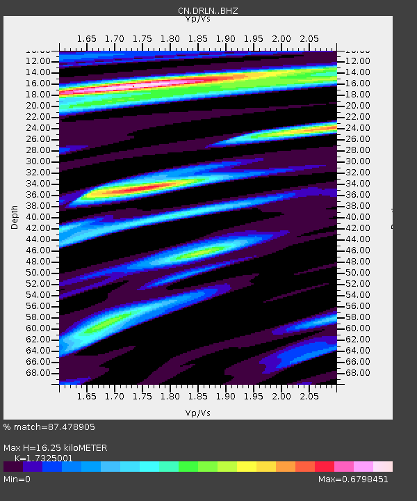
| Estimated Moho Depth: |
16.25 km |
| Estimated Crust Vp/Vs: |
1.73 |
| Assumed Crust Vp: |
6.35 km/s |
| Estimated Crust Vs: |
3.665 km/s |
| Estimated Crust Poisson's Ratio: |
0.25 |
|
| Radial Match: |
87.478905 % |
| Radial Bump: |
313 |
| Transverse Match: |
77.93021 % |
| Transverse Bump: |
395 |
| SOD ConfigId: |
3390531 |
| Insert Time: |
2019-04-12 04:05:55.965 +0000 |
| GWidth: |
2.5 |
| Max Bumps: |
400 |
| Tol: |
0.001 |
|
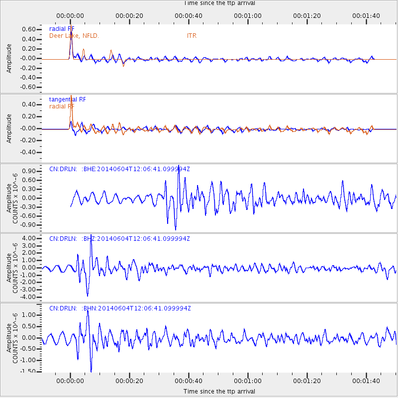
Signal To Noise
| Channel | StoN | STA | LTA |
| CN:DRLN: :BHZ:20140604T12:06:41.099994Z | 3.1211295 | 7.882258E-7 | 2.5254505E-7 |
| CN:DRLN: :BHN:20140604T12:06:41.099994Z | 2.524141 | 3.3834036E-7 | 1.3404178E-7 |
| CN:DRLN: :BHE:20140604T12:06:41.099994Z | 2.417068 | 2.9558393E-7 | 1.2229027E-7 |
| Arrivals |
| Ps | 2.0 SECOND |
| PpPs | 6.6 SECOND |
| PsPs/PpSs | 8.6 SECOND |


