You are here: Home > Network List > UW - Pacific Northwest Regional Seismic Network Stations List
> Station MRBL Marblemount, WA, USA > Earthquake Result Viewer
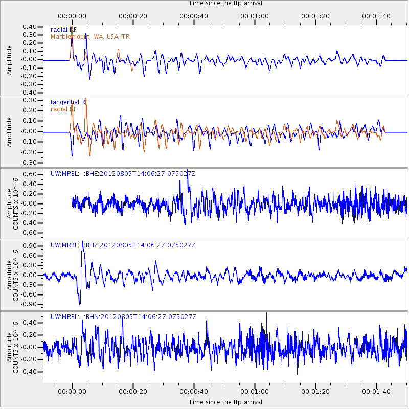
MRBL Marblemount, WA, USA - Earthquake Result Viewer
*The percent match for this event was below the threshold and hence no stack was calculated.
| Earthquake location: |
Fiji Islands Region |
| Earthquake latitude/longitude: |
-21.1/-178.4 |
| Earthquake time(UTC): |
2012/08/05 (218) 13:55:10 GMT |
| Earthquake Depth: |
484 km |
| Earthquake Magnitude: |
5.5 MB, 5.8 MW, 5.9 MW |
| Earthquake Catalog/Contributor: |
WHDF/NEIC |
|
| Network: |
UW Pacific Northwest Regional Seismic Network |
| Station: |
MRBL Marblemount, WA, USA |
| Lat/Lon: |
48.52 N/121.48 W |
| Elevation: |
75 m |
|
| Distance: |
85.9 deg |
| Az: |
33.933 deg |
| Baz: |
231.603 deg |
| Ray Param: |
$rayparam |
*The percent match for this event was below the threshold and hence was not used in the summary stack. |
|
| Radial Match: |
59.301918 % |
| Radial Bump: |
400 |
| Transverse Match: |
68.575516 % |
| Transverse Bump: |
400 |
| SOD ConfigId: |
469095 |
| Insert Time: |
2013-02-22 04:26:56.059 +0000 |
| GWidth: |
2.5 |
| Max Bumps: |
400 |
| Tol: |
0.001 |
|
Signal To Noise
| Channel | StoN | STA | LTA |
| UW:MRBL: :BHZ:20120805T14:06:27.075027Z | 8.987872 | 4.9472214E-7 | 5.50433E-8 |
| UW:MRBL: :BHN:20120805T14:06:27.075027Z | 1.9185059 | 1.6390787E-7 | 8.543516E-8 |
| UW:MRBL: :BHE:20120805T14:06:27.075027Z | 1.2805862 | 1.2621923E-7 | 9.856363E-8 |
| Arrivals |
| Ps | |
| PpPs | |
| PsPs/PpSs | |


