You are here: Home > Network List > G - GEOSCOPE Stations List
> Station TAM Tamanrasset, Algeria > Earthquake Result Viewer
TAM Tamanrasset, Algeria - Earthquake Result Viewer
| Earthquake location: |
Turkmenistan |
| Earthquake latitude/longitude: |
39.6/54.8 |
| Earthquake time(UTC): |
2000/12/06 (341) 17:11:06 GMT |
| Earthquake Depth: |
30 km |
| Earthquake Magnitude: |
6.7 MB, 7.5 MS, 7.0 MW, 6.9 ME |
| Earthquake Catalog/Contributor: |
WHDF/NEIC |
|
| Network: |
G GEOSCOPE |
| Station: |
TAM Tamanrasset, Algeria |
| Lat/Lon: |
22.79 N/5.53 E |
| Elevation: |
1377 m |
|
| Distance: |
44.8 deg |
| Az: |
263.128 deg |
| Baz: |
56.263 deg |
| Ray Param: |
0.071650125 |
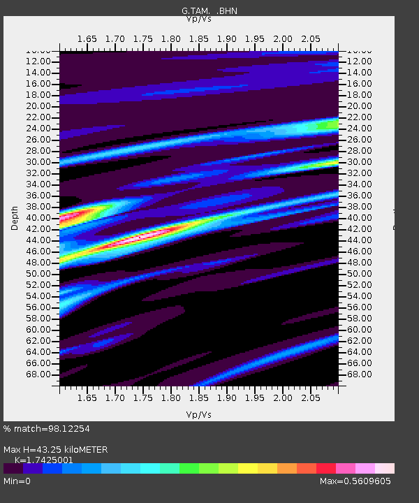
| Estimated Moho Depth: |
43.25 km |
| Estimated Crust Vp/Vs: |
1.74 |
| Assumed Crust Vp: |
6.61 km/s |
| Estimated Crust Vs: |
3.793 km/s |
| Estimated Crust Poisson's Ratio: |
0.25 |
|
| Radial Match: |
98.12254 % |
| Radial Bump: |
187 |
| Transverse Match: |
91.90343 % |
| Transverse Bump: |
400 |
| SOD ConfigId: |
20082 |
| Insert Time: |
2010-02-27 00:32:03.906 +0000 |
| GWidth: |
2.5 |
| Max Bumps: |
400 |
| Tol: |
0.001 |
|
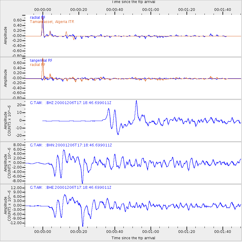
Signal To Noise
| Channel | StoN | STA | LTA |
| G:TAM: :BHN:20001206T17:18:46.699011Z | 1.9421531 | 2.3759654E-7 | 1.2233667E-7 |
| G:TAM: :BHE:20001206T17:18:46.699011Z | 5.5621405 | 4.810905E-7 | 8.649377E-8 |
| G:TAM: :BHZ:20001206T17:18:46.699011Z | 8.544921 | 1.0141662E-6 | 1.1868644E-7 |
| Arrivals |
| Ps | 5.2 SECOND |
| PpPs | 17 SECOND |
| PsPs/PpSs | 22 SECOND |


