You are here: Home > Network List > G - GEOSCOPE Stations List
> Station TAM Tamanrasset, Algeria > Earthquake Result Viewer
TAM Tamanrasset, Algeria - Earthquake Result Viewer
| Earthquake location: |
South Indian Ocean |
| Earthquake latitude/longitude: |
-13.8/97.5 |
| Earthquake time(UTC): |
2000/06/18 (170) 14:44:13 GMT |
| Earthquake Depth: |
10 km |
| Earthquake Magnitude: |
6.8 MB, 7.8 MS, 7.8 MW, 7.6 MW |
| Earthquake Catalog/Contributor: |
WHDF/NEIC |
|
| Network: |
G GEOSCOPE |
| Station: |
TAM Tamanrasset, Algeria |
| Lat/Lon: |
22.79 N/5.53 E |
| Elevation: |
1377 m |
|
| Distance: |
97.0 deg |
| Az: |
291.689 deg |
| Baz: |
101.989 deg |
| Ray Param: |
0.04035384 |
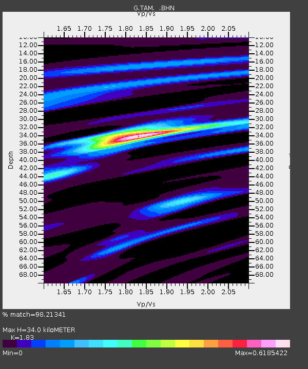
| Estimated Moho Depth: |
34.0 km |
| Estimated Crust Vp/Vs: |
1.83 |
| Assumed Crust Vp: |
6.61 km/s |
| Estimated Crust Vs: |
3.612 km/s |
| Estimated Crust Poisson's Ratio: |
0.29 |
|
| Radial Match: |
98.21341 % |
| Radial Bump: |
241 |
| Transverse Match: |
89.33975 % |
| Transverse Bump: |
400 |
| SOD ConfigId: |
3744 |
| Insert Time: |
2010-02-27 00:32:09.012 +0000 |
| GWidth: |
2.5 |
| Max Bumps: |
400 |
| Tol: |
0.001 |
|
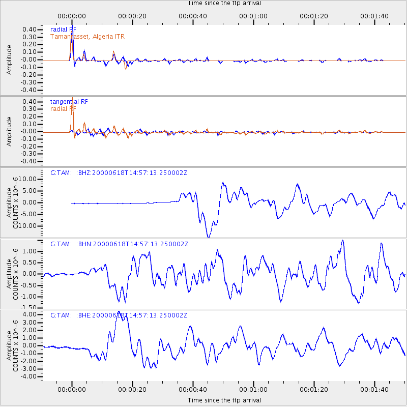
Signal To Noise
| Channel | StoN | STA | LTA |
| G:TAM: :BHN:20000618T14:57:13.250002Z | 1.1196158 | 6.183838E-8 | 5.523178E-8 |
| G:TAM: :BHE:20000618T14:57:13.250002Z | 3.6702757 | 2.600952E-7 | 7.0865305E-8 |
| G:TAM: :BHZ:20000618T14:57:13.250002Z | 7.706414 | 6.3295454E-7 | 8.213347E-8 |
| Arrivals |
| Ps | 4.4 SECOND |
| PpPs | 14 SECOND |
| PsPs/PpSs | 19 SECOND |


