You are here: Home > Network List > NX - Nanometrics Research Network Stations List
> Station STN12 Seismic station 12 > Earthquake Result Viewer
STN12 Seismic station 12 - Earthquake Result Viewer
| Earthquake location: |
Southeastern Alaska |
| Earthquake latitude/longitude: |
59.0/-136.7 |
| Earthquake time(UTC): |
2014/06/04 (155) 11:58:58 GMT |
| Earthquake Depth: |
10 km |
| Earthquake Magnitude: |
5.7 MWP, 5.8 ML, 5.8 MI |
| Earthquake Catalog/Contributor: |
NEIC PDE/NEIC COMCAT |
|
| Network: |
NX Nanometrics Research Network |
| Station: |
STN12 Seismic station 12 |
| Lat/Lon: |
36.26 N/96.49 W |
| Elevation: |
260 m |
|
| Distance: |
34.6 deg |
| Az: |
113.226 deg |
| Baz: |
323.951 deg |
| Ray Param: |
0.077678315 |
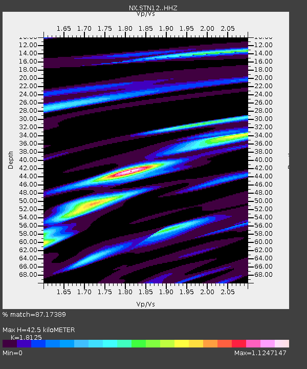
| Estimated Moho Depth: |
42.5 km |
| Estimated Crust Vp/Vs: |
1.81 |
| Assumed Crust Vp: |
6.483 km/s |
| Estimated Crust Vs: |
3.577 km/s |
| Estimated Crust Poisson's Ratio: |
0.28 |
|
| Radial Match: |
87.17389 % |
| Radial Bump: |
311 |
| Transverse Match: |
64.641335 % |
| Transverse Bump: |
400 |
| SOD ConfigId: |
3390531 |
| Insert Time: |
2019-04-12 04:08:08.497 +0000 |
| GWidth: |
2.5 |
| Max Bumps: |
400 |
| Tol: |
0.001 |
|

Signal To Noise
| Channel | StoN | STA | LTA |
| NX:STN12: :HHZ:20140604T12:05:16.680011Z | 7.5304317 | 5.869208E-7 | 7.793986E-8 |
| NX:STN12: :HH1:20140604T12:05:16.680011Z | 5.4066663 | 4.4175076E-7 | 8.170483E-8 |
| NX:STN12: :HH2:20140604T12:05:16.680011Z | 1.4676355 | 1.1533216E-7 | 7.858366E-8 |
| Arrivals |
| Ps | 5.8 SECOND |
| PpPs | 17 SECOND |
| PsPs/PpSs | 23 SECOND |


