You are here: Home > Network List > G - GEOSCOPE Stations List
> Station TAM Tamanrasset, Algeria > Earthquake Result Viewer
TAM Tamanrasset, Algeria - Earthquake Result Viewer
| Earthquake location: |
Myanmar |
| Earthquake latitude/longitude: |
26.9/97.2 |
| Earthquake time(UTC): |
2000/06/07 (159) 21:46:55 GMT |
| Earthquake Depth: |
33 km |
| Earthquake Magnitude: |
6.3 MB, 6.5 MS, 6.4 MW, 6.4 MW |
| Earthquake Catalog/Contributor: |
WHDF/NEIC |
|
| Network: |
G GEOSCOPE |
| Station: |
TAM Tamanrasset, Algeria |
| Lat/Lon: |
22.79 N/5.53 E |
| Elevation: |
1377 m |
|
| Distance: |
81.5 deg |
| Az: |
291.129 deg |
| Baz: |
64.551 deg |
| Ray Param: |
0.0475241 |
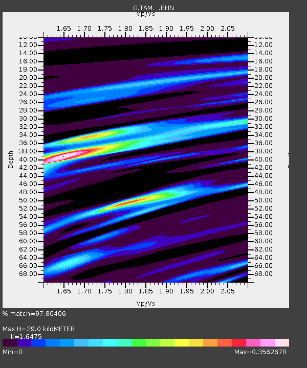
| Estimated Moho Depth: |
39.0 km |
| Estimated Crust Vp/Vs: |
1.65 |
| Assumed Crust Vp: |
6.61 km/s |
| Estimated Crust Vs: |
4.012 km/s |
| Estimated Crust Poisson's Ratio: |
0.21 |
|
| Radial Match: |
97.80406 % |
| Radial Bump: |
182 |
| Transverse Match: |
89.48316 % |
| Transverse Bump: |
400 |
| SOD ConfigId: |
3744 |
| Insert Time: |
2010-02-27 00:32:12.721 +0000 |
| GWidth: |
2.5 |
| Max Bumps: |
400 |
| Tol: |
0.001 |
|

Signal To Noise
| Channel | StoN | STA | LTA |
| G:TAM: :BHN:20000607T21:58:38.600012Z | 1.48218 | 7.590483E-8 | 5.1211615E-8 |
| G:TAM: :BHE:20000607T21:58:38.600012Z | 1.1404475 | 7.113093E-8 | 6.2371065E-8 |
| G:TAM: :BHZ:20000607T21:58:38.600012Z | 3.5911758 | 2.2609855E-7 | 6.295948E-8 |
| Arrivals |
| Ps | 3.9 SECOND |
| PpPs | 15 SECOND |
| PsPs/PpSs | 19 SECOND |


