You are here: Home > Network List > G - GEOSCOPE Stations List
> Station TAM Tamanrasset, Algeria > Earthquake Result Viewer
TAM Tamanrasset, Algeria - Earthquake Result Viewer
| Earthquake location: |
Hindu Kush Region, Afghanistan |
| Earthquake latitude/longitude: |
36.0/70.7 |
| Earthquake time(UTC): |
2000/05/12 (133) 23:10:29 GMT |
| Earthquake Depth: |
108 km |
| Earthquake Magnitude: |
6.2 MB, 6.3 MW, 6.3 MW |
| Earthquake Catalog/Contributor: |
WHDF/NEIC |
|
| Network: |
G GEOSCOPE |
| Station: |
TAM Tamanrasset, Algeria |
| Lat/Lon: |
22.79 N/5.53 E |
| Elevation: |
1377 m |
|
| Distance: |
57.3 deg |
| Az: |
275.826 deg |
| Baz: |
60.976 deg |
| Ray Param: |
0.063256934 |
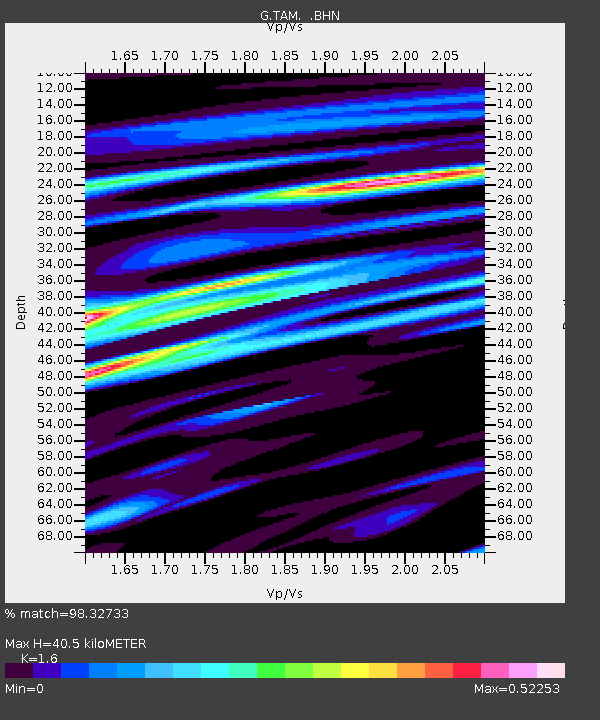
| Estimated Moho Depth: |
40.5 km |
| Estimated Crust Vp/Vs: |
1.60 |
| Assumed Crust Vp: |
6.61 km/s |
| Estimated Crust Vs: |
4.131 km/s |
| Estimated Crust Poisson's Ratio: |
0.18 |
|
| Radial Match: |
98.32733 % |
| Radial Bump: |
245 |
| Transverse Match: |
91.73768 % |
| Transverse Bump: |
400 |
| SOD ConfigId: |
3744 |
| Insert Time: |
2010-02-27 00:32:16.789 +0000 |
| GWidth: |
2.5 |
| Max Bumps: |
400 |
| Tol: |
0.001 |
|

Signal To Noise
| Channel | StoN | STA | LTA |
| G:TAM: :BHN:20000512T23:19:36.00002Z | 16.810322 | 5.4445127E-7 | 3.2387913E-8 |
| G:TAM: :BHE:20000512T23:19:36.00002Z | 20.914696 | 9.394606E-7 | 4.4918682E-8 |
| G:TAM: :BHZ:20000512T23:19:36.00002Z | 25.069206 | 2.2553486E-6 | 8.996489E-8 |
| Arrivals |
| Ps | 3.9 SECOND |
| PpPs | 15 SECOND |
| PsPs/PpSs | 19 SECOND |


