You are here: Home > Network List > NX - Nanometrics Research Network Stations List
> Station STN31 Seismic station 26 > Earthquake Result Viewer
STN31 Seismic station 26 - Earthquake Result Viewer
| Earthquake location: |
Southeastern Alaska |
| Earthquake latitude/longitude: |
59.0/-136.7 |
| Earthquake time(UTC): |
2014/06/04 (155) 11:58:58 GMT |
| Earthquake Depth: |
10 km |
| Earthquake Magnitude: |
5.7 MWP, 5.8 ML, 5.8 MI |
| Earthquake Catalog/Contributor: |
NEIC PDE/NEIC COMCAT |
|
| Network: |
NX Nanometrics Research Network |
| Station: |
STN31 Seismic station 26 |
| Lat/Lon: |
35.76 N/97.44 W |
| Elevation: |
329 m |
|
| Distance: |
34.5 deg |
| Az: |
114.846 deg |
| Baz: |
324.728 deg |
| Ray Param: |
0.07770091 |
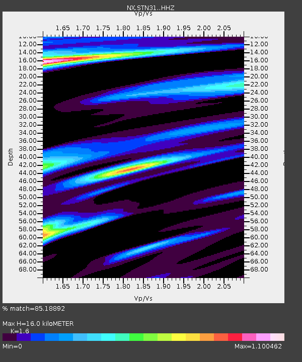
| Estimated Moho Depth: |
16.0 km |
| Estimated Crust Vp/Vs: |
1.60 |
| Assumed Crust Vp: |
6.426 km/s |
| Estimated Crust Vs: |
4.016 km/s |
| Estimated Crust Poisson's Ratio: |
0.18 |
|
| Radial Match: |
85.18892 % |
| Radial Bump: |
329 |
| Transverse Match: |
75.55259 % |
| Transverse Bump: |
340 |
| SOD ConfigId: |
3390531 |
| Insert Time: |
2019-04-12 04:08:15.415 +0000 |
| GWidth: |
2.5 |
| Max Bumps: |
400 |
| Tol: |
0.001 |
|

Signal To Noise
| Channel | StoN | STA | LTA |
| NX:STN31: :HHZ:20140604T12:05:16.300006Z | 7.804381 | 7.4333497E-7 | 9.5245866E-8 |
| NX:STN31: :HH1:20140604T12:05:16.300006Z | 0.9455745 | 8.84074E-8 | 9.349596E-8 |
| NX:STN31: :HH2:20140604T12:05:16.300006Z | 2.168329 | 2.7713702E-7 | 1.2781132E-7 |
| Arrivals |
| Ps | 1.6 SECOND |
| PpPs | 5.9 SECOND |
| PsPs/PpSs | 7.6 SECOND |


