You are here: Home > Network List > CI - Caltech Regional Seismic Network Stations List
> Station SMM Simmler, CA, USA > Earthquake Result Viewer
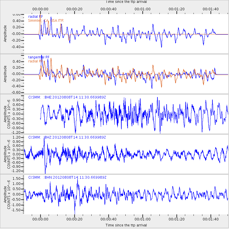
SMM Simmler, CA, USA - Earthquake Result Viewer
*The percent match for this event was below the threshold and hence no stack was calculated.
| Earthquake location: |
Alaska Peninsula |
| Earthquake latitude/longitude: |
54.9/-161.2 |
| Earthquake time(UTC): |
2012/08/08 (221) 14:05:17 GMT |
| Earthquake Depth: |
43 km |
| Earthquake Magnitude: |
5.6 MB, 5.2 MW, 5.1 MW |
| Earthquake Catalog/Contributor: |
WHDF/NEIC |
|
| Network: |
CI Caltech Regional Seismic Network |
| Station: |
SMM Simmler, CA, USA |
| Lat/Lon: |
35.31 N/120.00 W |
| Elevation: |
599 m |
|
| Distance: |
34.4 deg |
| Az: |
107.462 deg |
| Baz: |
317.621 deg |
| Ray Param: |
$rayparam |
*The percent match for this event was below the threshold and hence was not used in the summary stack. |
|
| Radial Match: |
49.22333 % |
| Radial Bump: |
400 |
| Transverse Match: |
64.104774 % |
| Transverse Bump: |
400 |
| SOD ConfigId: |
469095 |
| Insert Time: |
2013-02-22 04:44:39.947 +0000 |
| GWidth: |
2.5 |
| Max Bumps: |
400 |
| Tol: |
0.001 |
|
Signal To Noise
| Channel | StoN | STA | LTA |
| CI:SMM: :BHZ:20120808T14:11:30.669989Z | 2.2322893 | 5.707656E-7 | 2.5568622E-7 |
| CI:SMM: :BHN:20120808T14:11:30.669989Z | 0.9616086 | 3.137937E-7 | 3.2632164E-7 |
| CI:SMM: :BHE:20120808T14:11:30.669989Z | 1.0144691 | 4.0348522E-7 | 3.977304E-7 |
| Arrivals |
| Ps | |
| PpPs | |
| PsPs/PpSs | |


