You are here: Home > Network List > TA - USArray Transportable Network (new EarthScope stations) Stations List
> Station F61A St Evariste, QC, CAN > Earthquake Result Viewer
F61A St Evariste, QC, CAN - Earthquake Result Viewer
| Earthquake location: |
Southeastern Alaska |
| Earthquake latitude/longitude: |
59.0/-136.7 |
| Earthquake time(UTC): |
2014/06/04 (155) 11:58:58 GMT |
| Earthquake Depth: |
10 km |
| Earthquake Magnitude: |
5.7 MWP, 5.8 ML, 5.8 MI |
| Earthquake Catalog/Contributor: |
NEIC PDE/NEIC COMCAT |
|
| Network: |
TA USArray Transportable Network (new EarthScope stations) |
| Station: |
F61A St Evariste, QC, CAN |
| Lat/Lon: |
45.97 N/70.99 W |
| Elevation: |
350 m |
|
| Distance: |
40.4 deg |
| Az: |
78.867 deg |
| Baz: |
313.264 deg |
| Ray Param: |
0.074443646 |
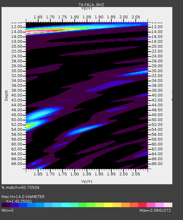
| Estimated Moho Depth: |
14.0 km |
| Estimated Crust Vp/Vs: |
1.61 |
| Assumed Crust Vp: |
6.419 km/s |
| Estimated Crust Vs: |
3.981 km/s |
| Estimated Crust Poisson's Ratio: |
0.19 |
|
| Radial Match: |
80.70506 % |
| Radial Bump: |
400 |
| Transverse Match: |
53.409733 % |
| Transverse Bump: |
400 |
| SOD ConfigId: |
3390531 |
| Insert Time: |
2019-04-12 04:09:03.951 +0000 |
| GWidth: |
2.5 |
| Max Bumps: |
400 |
| Tol: |
0.001 |
|
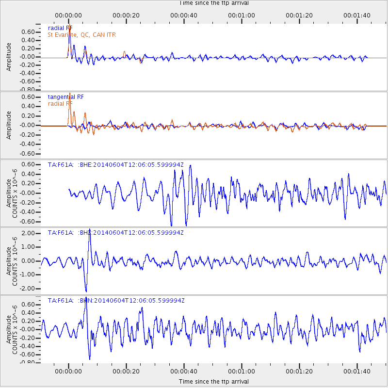
Signal To Noise
| Channel | StoN | STA | LTA |
| TA:F61A: :BHZ:20140604T12:06:05.599994Z | 1.6368178 | 2.5403028E-7 | 1.5519765E-7 |
| TA:F61A: :BHN:20140604T12:06:05.599994Z | 1.3821789 | 1.3154067E-7 | 9.516907E-8 |
| TA:F61A: :BHE:20140604T12:06:05.599994Z | 1.5145172 | 1.9191086E-7 | 1.2671421E-7 |
| Arrivals |
| Ps | 1.4 SECOND |
| PpPs | 5.3 SECOND |
| PsPs/PpSs | 6.7 SECOND |


