You are here: Home > Network List > IW - Intermountain West Stations List
> Station IMW Indian Meadow, Wyoming, USA > Earthquake Result Viewer
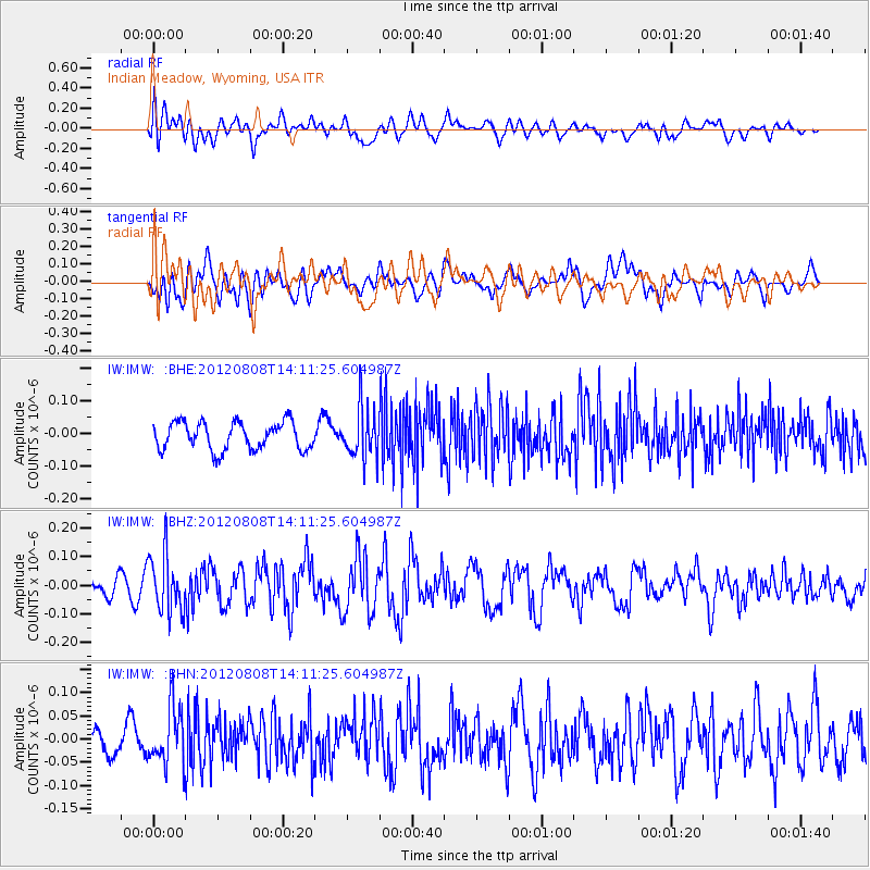
IMW Indian Meadow, Wyoming, USA - Earthquake Result Viewer
*The percent match for this event was below the threshold and hence no stack was calculated.
| Earthquake location: |
Alaska Peninsula |
| Earthquake latitude/longitude: |
54.9/-161.2 |
| Earthquake time(UTC): |
2012/08/08 (221) 14:05:17 GMT |
| Earthquake Depth: |
43 km |
| Earthquake Magnitude: |
5.6 MB, 5.2 MW, 5.1 MW |
| Earthquake Catalog/Contributor: |
WHDF/NEIC |
|
| Network: |
IW Intermountain West |
| Station: |
IMW Indian Meadow, Wyoming, USA |
| Lat/Lon: |
43.90 N/110.94 W |
| Elevation: |
2646 m |
|
| Distance: |
33.8 deg |
| Az: |
87.713 deg |
| Baz: |
306.992 deg |
| Ray Param: |
$rayparam |
*The percent match for this event was below the threshold and hence was not used in the summary stack. |
|
| Radial Match: |
62.025356 % |
| Radial Bump: |
400 |
| Transverse Match: |
58.582985 % |
| Transverse Bump: |
400 |
| SOD ConfigId: |
469095 |
| Insert Time: |
2013-02-22 04:48:16.519 +0000 |
| GWidth: |
2.5 |
| Max Bumps: |
400 |
| Tol: |
0.001 |
|
Signal To Noise
| Channel | StoN | STA | LTA |
| IW:IMW: :BHZ:20120808T14:11:25.604987Z | 1.9059302 | 1.01779364E-7 | 5.340141E-8 |
| IW:IMW: :BHN:20120808T14:11:25.604987Z | 2.0501332 | 6.050063E-8 | 2.9510584E-8 |
| IW:IMW: :BHE:20120808T14:11:25.604987Z | 1.8122009 | 7.6444245E-8 | 4.2183096E-8 |
| Arrivals |
| Ps | |
| PpPs | |
| PsPs/PpSs | |


