You are here: Home > Network List > TA - USArray Transportable Network (new EarthScope stations) Stations List
> Station S57A Dark Hollow, Roseland, VA, USA > Earthquake Result Viewer
S57A Dark Hollow, Roseland, VA, USA - Earthquake Result Viewer
| Earthquake location: |
Southeastern Alaska |
| Earthquake latitude/longitude: |
59.0/-136.7 |
| Earthquake time(UTC): |
2014/06/04 (155) 11:58:58 GMT |
| Earthquake Depth: |
10 km |
| Earthquake Magnitude: |
5.7 MWP, 5.8 ML, 5.8 MI |
| Earthquake Catalog/Contributor: |
NEIC PDE/NEIC COMCAT |
|
| Network: |
TA USArray Transportable Network (new EarthScope stations) |
| Station: |
S57A Dark Hollow, Roseland, VA, USA |
| Lat/Lon: |
37.76 N/78.95 W |
| Elevation: |
264 m |
|
| Distance: |
42.2 deg |
| Az: |
93.99 deg |
| Baz: |
319.348 deg |
| Ray Param: |
0.07331824 |
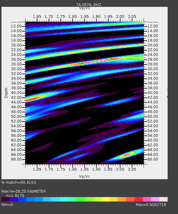
| Estimated Moho Depth: |
26.25 km |
| Estimated Crust Vp/Vs: |
1.92 |
| Assumed Crust Vp: |
6.419 km/s |
| Estimated Crust Vs: |
3.348 km/s |
| Estimated Crust Poisson's Ratio: |
0.31 |
|
| Radial Match: |
80.4103 % |
| Radial Bump: |
318 |
| Transverse Match: |
60.726974 % |
| Transverse Bump: |
400 |
| SOD ConfigId: |
3390531 |
| Insert Time: |
2019-04-12 04:09:29.598 +0000 |
| GWidth: |
2.5 |
| Max Bumps: |
400 |
| Tol: |
0.001 |
|

Signal To Noise
| Channel | StoN | STA | LTA |
| TA:S57A: :BHZ:20140604T12:06:20.650012Z | 1.3616253 | 1.4926016E-7 | 1.0961912E-7 |
| TA:S57A: :BHN:20140604T12:06:20.650012Z | 2.2776103 | 1.5595275E-7 | 6.84721E-8 |
| TA:S57A: :BHE:20140604T12:06:20.650012Z | 1.4668148 | 1.1105172E-7 | 7.570944E-8 |
| Arrivals |
| Ps | 4.0 SECOND |
| PpPs | 11 SECOND |
| PsPs/PpSs | 15 SECOND |


