You are here: Home > Network List > G - GEOSCOPE Stations List
> Station TAM Tamanrasset, Algeria > Earthquake Result Viewer
TAM Tamanrasset, Algeria - Earthquake Result Viewer
| Earthquake location: |
Iceland |
| Earthquake latitude/longitude: |
64.0/-20.5 |
| Earthquake time(UTC): |
2000/06/17 (169) 15:40:41 GMT |
| Earthquake Depth: |
10 km |
| Earthquake Magnitude: |
5.7 MB, 6.6 MS, 6.8 MW, 6.5 MW |
| Earthquake Catalog/Contributor: |
WHDF/NEIC |
|
| Network: |
G GEOSCOPE |
| Station: |
TAM Tamanrasset, Algeria |
| Lat/Lon: |
22.79 N/5.53 E |
| Elevation: |
1377 m |
|
| Distance: |
44.6 deg |
| Az: |
144.823 deg |
| Baz: |
344.009 deg |
| Ray Param: |
0.071796216 |
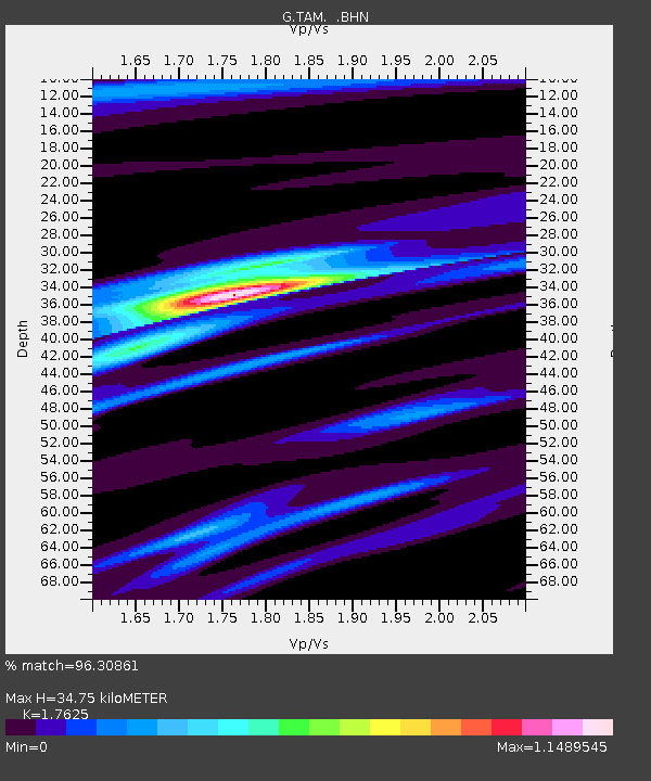
| Estimated Moho Depth: |
34.75 km |
| Estimated Crust Vp/Vs: |
1.76 |
| Assumed Crust Vp: |
6.61 km/s |
| Estimated Crust Vs: |
3.75 km/s |
| Estimated Crust Poisson's Ratio: |
0.26 |
|
| Radial Match: |
96.30861 % |
| Radial Bump: |
248 |
| Transverse Match: |
92.99496 % |
| Transverse Bump: |
400 |
| SOD ConfigId: |
3744 |
| Insert Time: |
2010-02-27 00:32:30.613 +0000 |
| GWidth: |
2.5 |
| Max Bumps: |
400 |
| Tol: |
0.001 |
|
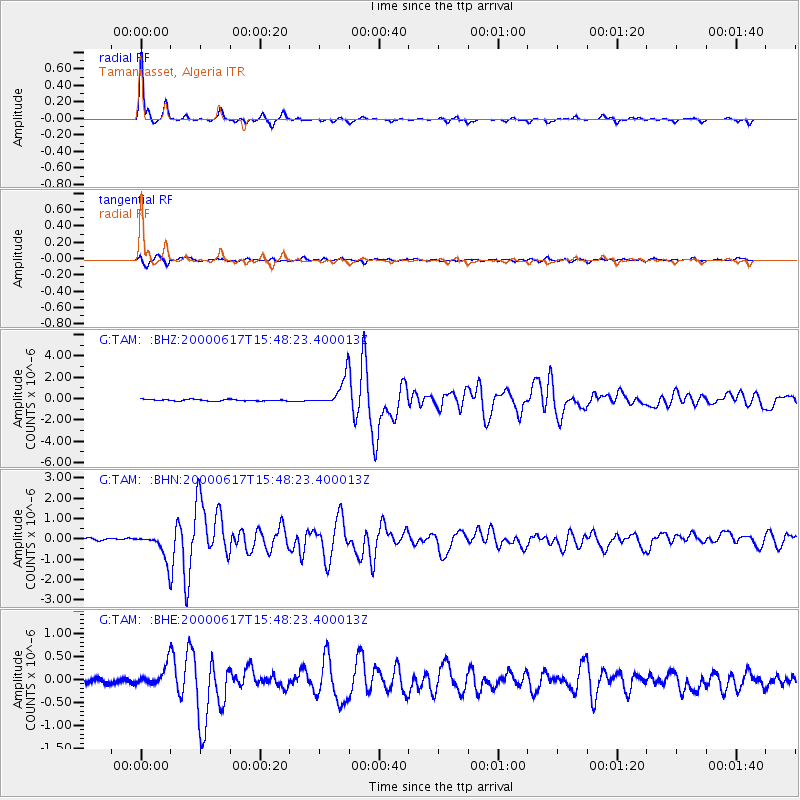
Signal To Noise
| Channel | StoN | STA | LTA |
| G:TAM: :BHN:20000617T15:48:23.400013Z | 12.464443 | 6.963988E-7 | 5.587083E-8 |
| G:TAM: :BHE:20000617T15:48:23.400013Z | 4.5936756 | 2.3143843E-7 | 5.0381974E-8 |
| G:TAM: :BHZ:20000617T15:48:23.400013Z | 19.646984 | 1.3460456E-6 | 6.851156E-8 |
| Arrivals |
| Ps | 4.3 SECOND |
| PpPs | 14 SECOND |
| PsPs/PpSs | 18 SECOND |


